Old Maps of Union County, Kentucky for Hiking & Exploration
Hike through history with 134 historic maps of Union County. Explore old trails, ghost towns, and forgotten backroads — perfect for outdoor adventurers and local explorers.
- Rediscover forgotten places: Map out old mining camps, roads, and footpaths that no longer exist on modern maps.
- Layer with modern tools: Combine with LiDAR or satellite views to plan hikes through historical terrain.
- Made for exploration: Popular among hikers, overlanders, and local history lovers.
Use these maps to find adventure and explore the hidden past of Union County.
Union County, KY maps
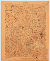
(134)- 1905 Map of New Haven, 1966 Print
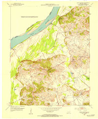
 1905 New Haven1966 Print · USGSThe tri-state border region along the Wabash and Ohio Rivers is captured here during the early twentieth century. Genealogists can trace family footprints in New Haven, Ridgway, and Herald, or locate historic crossings like Mackeys Ferry and Dogtown Ferry.
 - 1906 Map of New Haven
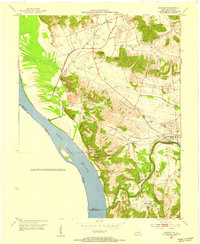
 1906 New Haven1906 Print · USGSThe Wabash River borderlands of Illinois and Indiana come to life in this early century survey of the river's winding oxbows and swampy bottoms. Genealogists can trace early homesteads near New Haven, Concord Emma P O, and the river landings at Dogtown Ferry.4 unique versions available
 - 1906 Map of Sebree
 1906 Sebree1906 Print · USGSWestern Kentucky at the dawn of the twentieth century was a landscape of rail-connected towns and crossroads hamlets. Genealogists can trace family footprints near Sebree and Dixon, or locate vanished schoolhouses and churches like Oakland Schoolhouse and Mt Pleasant Church.3 unique versions available
 - 1907 Map of Morganfield
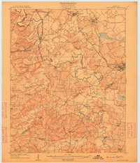
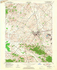
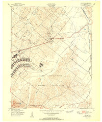
 1907 Morganfield1907 Print · USGSUnion County during the first decade of the twentieth century shows a landscape transitioning between its agrarian roots and a growing rail economy. Genealogists can locate family landmarks like Waggoner Church, the remote Topeka Crossroads, and the settlement at Seven Gums.3 unique versions available
 - 1909 Map of Providence
 1909 Providence1909 Print · USGSWestern Kentucky's coal and river country comes alive in the early 1900s as railroads begin to reshape the Tradewater Valley. Genealogists and researchers can trace old river crossings like Rices Mill Jericho Ford or locate lost community landmarks such as Numms Sta Gladstone PO and Rock Spring Church.3 unique versions available
 - 1916 Map of Shawneetown
 1916 Shawneetown1916 Print · USGSThe Illinois-Kentucky borderlands thrived as a river-and-rail corridor during the early twentieth century. Genealogists and historians can trace the foundations of local life through dozens of rural schools and industrial sites like Saline Mines, Caseyville, and Westwood Cemetery.5 unique versions available
 - 1917 Map of Uniontown
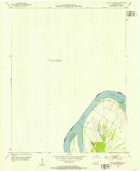
 1917 Uniontown1917 Print · USGSThe Ohio River borderlands between Kentucky and Indiana were bustling with river and rail activity during the First World War. Local historians can trace dozens of rural school sites like Bethlehem School and river landmarks such as Slim Island and Hovey Lake.6 unique versions available
 - 1949 Map of Paducah
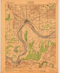
 1949 Paducah1949 Print · USGSThe confluence of the Ohio, Mississippi, Tennessee, and Cumberland rivers at the close of the 1940s reveals a region bound by water and rail. Researchers can trace historic river landings, timberlands in the Shawnee National Forest, and the coal-mining infrastructure around West Frankfort and Herrin.2 unique versions available
 - 1949 Map of New Haven, 1958 Print
 1949 New Haven1958 Print · USGSSouthern Illinois and the Indiana borderlands are captured here in the late 1940s, highlighting the intricate river-and-rail landscape at the confluence of the Wabash and Ohio. Genealogists and historians can trace old homesteads and post offices like Concord Emma PO, Ridgway, and New Haven.
 - 1949 Map of Morganfield, 1966 Print
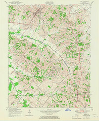
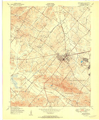
 1949 Morganfield1966 Print · USGSMorganfield and the surrounding Union County countryside are documented here during the post-war era as military activity and resource extraction shaped the land. Genealogists can locate numerous family burial grounds including Waller Cem and Sugg Cem, alongside landmarks like Antioch Ch.
 - 1949 Map of Poole, 1967 Print
 1949 Poole1967 Print · USGSKentucky's tri-county borderlands come into focus in the late 1940s, showing a landscape defined by military land use and the Illinois Central railroad. Genealogists can locate numerous family-named burial sites like Liles Cem and Sisk Cem near the Camp Breckinridge Military Reservation.
 - 1950 Map of Paducah
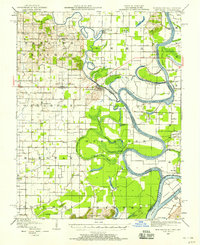
 1950 Paducah1950 Print · USGSThe confluence of the great midwestern rivers defines this mid-century landscape at the intersection of Illinois, Kentucky, and Missouri. Genealogists and historians can trace the rail-and-river economy through the hubs of Paducah, Cairo, and Metropolis or locate family roots near the Wildcat Hills.
 - 1951 Map of Dixon
 1951 Dixon1951 Print · USGSDixon and northern Webster County are captured here in the early fifties during the height of activity at the nearby military reservation. Genealogists can locate dozens of family burial sites including Crews Cem and Yates Cem, while tracing the rural settlements of Tilden and Wanamaker.
 - 1951 Map of Poole
 1951 Poole1951 Print · USGSNorthwest Kentucky is captured here during the early Cold War era as military and industrial interests expanded. Genealogists and local historians can trace family plots like Watson Cem and explore the rail corridor of the Illinois Central.
 - 1951 Map of Waverly
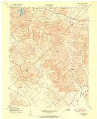
 1951 Waverly1951 Print · USGSUnion County is seen here in the early postwar years, when military expansion and oil exploration began to reshape the rural landscape. Genealogists and historians can trace the foundations of Camp Breckinridge, old family burial grounds like Odd Fellows Cem, and the rail-side community of Waverly.
 - 1951 Map of Bordley
 1951 Bordley1951 Print · USGSThe rural border of Union and Webster counties appears here in the early fifties, just after the establishment of Camp Breckinridge Military Reservation. Genealogists can trace family landmarks like the Odd Fellows Cem, Walnut Grove Ch, and the settlement of Bordley.
 - 1951 Map of Sturgis
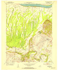
 1951 Sturgis1951 Print · USGSThe coal and rail hub of Sturgis thrives in the early fifties at the meeting of the Illinois Central and Western Kentucky lines. Trace local heritage through the Poplar Ridge Mine, Pythian Ridge Cem, and Bethany Church.
 - 1951 Map of Morganfield
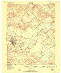
 1951 Morganfield1951 Print · USGSIn Union County at the dawn of the fifties, this area was defined by the intersection of military growth and rural Kentucky life. Researchers can trace the extensive Camp Breckinridge footprint or locate family markers at Odd Fellows Cemetery and Williams Cem.
 - 1952 Map of Mount Vernon, 1953 Print
 1952 Mount Vernon1953 Print · USGSThe Ohio River bend south of Mount Vernon comes into focus in the early fifties, marking the intersection of Posey, Henderson, and Union counties. Genealogists and river historians can trace the contours of Slim Island and the marshy edges of Grassy Pond.2 unique versions available
 - 1952 Map of Uniontown, 1954 Print
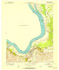 1952 Uniontown1954 Print · USGSUniontown and the surrounding river bottomlands are captured here in the early 1950s at a time of active petroleum extraction. Researchers can locate St Agnes Ch, trace the old Ferry crossing, and identify numerous Oil Wells across the landscape.2 unique versions available
 - 1952 Map of Smith Mills, 1954 Print
 1952 Smith Mills1954 Print · USGSThe Ohio River bottomlands of Henderson County come into focus during the early 1950s, showing a landscape of sloughs and rising petroleum production. Genealogists can locate family landmarks like Smith Mills Cem and St Francis Ch alongside the many Oil Wells near Alzey.2 unique versions available
 - 1953 Map of Wabash Island
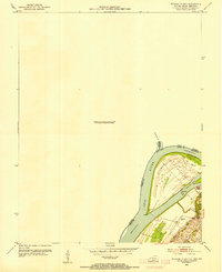 1953 Wabash Island1953 Print · USGSThe tri-state confluence of Illinois, Indiana, and Kentucky is captured here in the early fifties at a time when river transport and local industry intersected. Genealogists and researchers can locate the Reburn Ch, a Pvt Ferry crossing, and an active Oil Well on Wabash Island.2 unique versions available
 - 1953 Map of Grove Center, 1954 Print
 1953 Grove Center1954 Print · USGSUnion County, Kentucky, was a landscape of river-fed bottomlands and rising hills in the early fifties. Genealogists and local historians can trace the paths to Spring Grove Ch, locate Oil Wells in the eastern hills, or follow the Illinois Central through Grove Center.
 - 1953 Map of Dekoven, 1954 Print
 1953 Dekoven1954 Print · USGSWestern Kentucky coal and river culture meet in the early fifties along the Ohio River. Researchers can trace the rail networks of the West Kentucky Coal Company and locate old sites like Caseyville, Dekoven, and St Ambrose Ch.
 - 1954 Map of Evansville
 1954 Evansville1954 Print · USGSThe Ohio River borderlands between Indiana and Kentucky appear here during a period of robust industrial and military growth. Genealogists and researchers can trace the rail corridors of the Illinois Central and find landmarks like US Lock and Dam No 48 or Camp Breckinridge.
Showing maps 1-25 of 134
Top cities of Union County
Frequently asked questions
- What are the different types of historical maps available for Union County?
- What is the oldest map of Union County?
- Where can I purchase historical maps of Union County for my home or office?
- Where can I download high-res historical maps of Union County?
- Are there historical topographic maps available for Union County?
- Is there historical aerial imagery available for Union County?
- Where are historical maps of Union County sourced from?