1980s Maps of Union County, Kentucky
Explore 9 historic maps of Union County from the 1980s. These maps offer a rare glimpse into what life looked like during the 1980s — showing old roads, neighborhoods, homes, and landmarks that have changed or disappeared over time.
Whether you're researching your family's past, planning a metal detecting trip, or studying how Union County's landscape evolved across the 1980s, these high-resolution maps are a powerful tool for exploring the history of this region.
- Focus on a specific era: All maps on this page are from the 1980s, giving you a focused view of this time period.
- See what’s changed: Compare century-old streets, trails, and buildings to today's modern landscape using overlays and satellite layers.
- Research with precision: Use these maps for genealogy, historical research, land use analysis, or educational projects.
- View, download, or print: Maps are fully viewable online in high resolution, and can be downloaded or printed for your own records.
Start exploring Union County's history through authentic maps from the 1980s. This is your window into the past.
Union County, KY maps
(9)- 1981 Map of Smith Mills
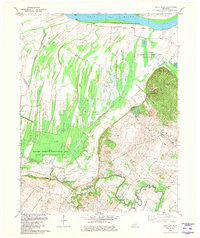 1981 Smith Mills1981 Print · USGSThe Ohio River wetlands and Henderson County oil fields are captured here in the early 1980s. Local researchers can trace the rural roads connecting Smith Mills and Hitesville or locate specific Oil Wells and the Saverheber Unit.
 - 1981 Map of Uniontown
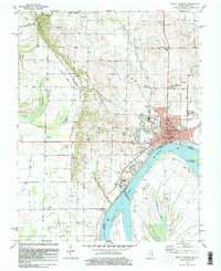
 1981 Uniontown1981 Print · USGSThe riverfront town of Uniontown and its surrounding floodplains are captured here in the early eighties as a landscape of managed wetlands and river industry. Researchers can trace the river's path through Mississippi Bend or locate local landmarks like St Agnes Cem and the Uniontown Locks and Dam.
 - 1981 Map of Mount Vernon
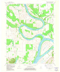
 1981 Mount Vernon1981 Print · USGSMount Vernon and the winding Ohio River shoreline appear here in the early eighties, capturing a landscape of active river industry and rural family life. Genealogists can trace sites like Belle Fontaine Cem, Zoar Ch, and the defunct Dead Mans Crossing along the rail lines.
 - 1981 Map of Wabash Island
 1981 Wabash Island1981 Print · USGSThe tri-state borderlands of Illinois, Indiana, and Kentucky are defined by the winding Wabash River and Ohio River in the early eighties. Genealogists and local historians can trace family sites at Oak Grove and Rowe Cem or locate the old Private Ferry crossing.
 - 1983 Map of Madisonville, 1984 Print
 1983 Madisonville1984 Print · USGSThe Western Kentucky coalfields and river valleys come into focus in the early eighties as the rail-and-river economy matured. Genealogists can trace family footprints across Dawson Springs, Mortons Gap, and Slaughters, or locate landmarks like Shake Rag Hills and Lake Malone.
 - 1984 Map of West Frankfort, 1985 Print
 1984 West Frankfort1985 Print · USGSSouthern Illinois at the peak of late-century coal and oil production reveals a complex landscape of industry and conservation. Genealogists and historians can trace rail-served mining hubs like Orient No. 3 Mine and the historic riverfront at Old Shawneetown.
 - 1986 Map of Evansville
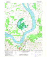
 1986 Evansville1986 Print · USGSThe Ohio River valley thrives in the mid-1980s as a hub of river commerce, industry, and natural preservation spanning the Indiana-Kentucky border. Genealogists and historians can locate remote landmarks like Dead Mans Cem, Lippe Church, and the riverside community of Scuffletown.
 - 1987 Map of West Frankfort
 1987 West Frankfort1987 Print · USGSSouthern Illinois in the late eighties shows a landscape defined by the coal and river economies. Researchers can trace the extensive Strip Mine works and historic settlements like Shawneetown and Carriers Mills along the Illinois Central Railroad.
 - 1987 Map of Paducah, 1988 Print
 1987 Paducah1988 Print · USGSThe Lower Ohio Valley and the Illinois Ozarks come alive in this late twentieth-century regional survey. Genealogists and local historians can trace river-town roots and state park landmarks from Metropolis to Cape Girardeau and Trail of Tears State Park.
End of results
Showing maps 1-9 of 9
Top cities of Union County
Frequently asked questions
- What are the different types of historical maps available for Union County?
- What is the oldest map of Union County?
- Where can I purchase historical maps of Union County for my home or office?
- Where can I download high-res historical maps of Union County?
- Are there historical topographic maps available for Union County?
- Is there historical aerial imagery available for Union County?
- Where are historical maps of Union County sourced from?