1970s Maps of Warren County, Kentucky
Explore 7 historic maps of Warren County from the 1970s. These maps offer a rare glimpse into what life looked like during the 1970s — showing old roads, neighborhoods, homes, and landmarks that have changed or disappeared over time.
Whether you're researching your family's past, planning a metal detecting trip, or studying how Warren County's landscape evolved across the 1970s, these high-resolution maps are a powerful tool for exploring the history of this region.
- Focus on a specific era: All maps on this page are from the 1970s, giving you a focused view of this time period.
- See what’s changed: Compare century-old streets, trails, and buildings to today's modern landscape using overlays and satellite layers.
- Research with precision: Use these maps for genealogy, historical research, land use analysis, or educational projects.
- View, download, or print: Maps are fully viewable online in high resolution, and can be downloaded or printed for your own records.
Start exploring Warren County's history through authentic maps from the 1970s. This is your window into the past.
Warren County, KY maps
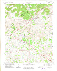
(7)- 1973 Map of Hadley, 1974 Print
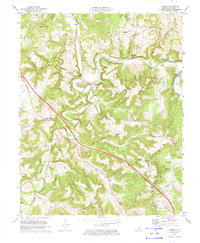 1973 Hadley1974 Print · USGSThe Barren River meanders through Warren County in the early seventies, defining a landscape of deep river bends and rural crossroads. Genealogists and local historians can locate several country churches, including Glen Lily Ch and Highland Ch, alongside landmarks like Sallys Rock.
 - 1973 Map of Morgantown, 1974 Print
 1973 Morgantown1974 Print · USGSMorgantown and the Green River corridor are captured here in the early 1970s, as new parkway construction began to bisect the traditional mining and farming landscape. Genealogists can locate family names and burial sites at Riverview Cem, Hill Haven Memory Gardens, and Sandy Creek Cem.
 - 1973 Map of Rockfield, 1974 Print
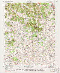
 1973 Rockfield1974 Print · USGSWarren County in the 1970s is a landscape of active oil fields and traditional rural rail stops. Genealogists and historians can trace the foundations of local life through Rockfield Sch, Cedar Grove Ch, and the extensive network of Oil Wells surrounding Browning.
 - 1973 Map of Sugar Grove, 1974 Print
 1973 Sugar Grove1974 Print · USGSThe rural borderlands of Butler and Warren counties are captured here in the early 1970s, showcasing a landscape of dispersed family farms and wooded ridges. Genealogists can locate family-named sites like McKinney Cem and local centers such as Sugar Grove and Richelieu.
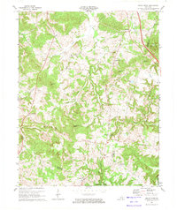
 - 1973 Map of Park City, 1974 Print
 1973 Park City1974 Print · USGSPark City and the surrounding knobs of Barren County are captured in the early seventies, just as the regional highway network was expanding. Genealogists and cave enthusiasts can trace family sites and local landmarks like Diamond Caverns, Zion Cem Ch, and the rural community of Merry Oaks.
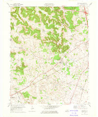
 - 1979 Map of Woodburn, 1984 Print
 1979 Woodburn1984 Print · USGSWarren and Simpson County at the end of the seventies show a landscape of traditional crossroads communities and institutional foundations. Genealogists can locate family landmarks like Old Zion Ch, the County Home, and the railroad village of Woodburn.
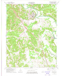
 - 1979 Map of Rockfield, 1988 Print
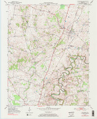
 1979 Rockfield1988 Print · USGSWarren County’s rail and energy landscape comes into focus during the 1970s as the Louisville and Nashville line passes through small rural hubs. Genealogists and historians can trace local family landmarks like Millikens Chapel, Pleasant Hill Cem, and the community at Rockfield.
End of results
Showing maps 1-7 of 7
Top cities of Warren County
- Bowling Green historical maps
- Smiths Grove historical maps
- Plum Springs historical maps
- Woodburn historical maps
- Oakland historical maps
Frequently asked questions
- What are the different types of historical maps available for Warren County?
- What is the oldest map of Warren County?
- Where can I purchase historical maps of Warren County for my home or office?
- Where can I download high-res historical maps of Warren County?
- Are there historical topographic maps available for Warren County?
- Is there historical aerial imagery available for Warren County?
- Where are historical maps of Warren County sourced from?