1960s Maps of Oakdale, Louisiana
Explore 3 historic maps of Oakdale from the 1960s. These maps offer a rare glimpse into what life looked like during the 1960s — showing old roads, neighborhoods, homes, and landmarks that have changed or disappeared over time.
Whether you're researching your family's past, planning a metal detecting trip, or studying how Oakdale's landscape evolved across the 1960s, these high-resolution maps are a powerful tool for exploring the history of this region.
- Focus on a specific era: All maps on this page are from the 1960s, giving you a focused view of this time period.
- See what’s changed: Compare century-old streets, trails, and buildings to today's modern landscape using overlays and satellite layers.
- Research with precision: Use these maps for genealogy, historical research, land use analysis, or educational projects.
- View, download, or print: Maps are fully viewable online in high resolution, and can be downloaded or printed for your own records.
Start exploring Oakdale's history through authentic maps from the 1960s. This is your window into the past.
Oakdale, LA maps
(3)- 1968 Map of Oakdale, 1970 Print
 1968 Oakdale1970 Print · USGSAllen Parish and Rapides Parish intersect during a period of industrial and aviation growth in the late sixties. Genealogists and local historians can trace family sites like Osburn Willis Cem, Bethany Ch, and the rural community of Union Hill.
 - 1968 Map of Oakdale, 1970 Print
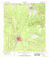
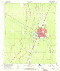 1968 Oakdale1970 Print · USGSOakdale serves as a busy rail and aviation hub in the late sixties, where the timberlands meet industrial infrastructure. Researchers can trace family roots through several local landmarks like Oak Hill Cem, Mt Vernon Ch, and the Sacred Heart Cem.3 unique versions available
 - 1968 Map of Beaver, 1970 Print
 1968 Beaver1970 Print · USGSEvangeline and Allen Parishes are captured here in the late sixties, showing a landscape defined by timber, bayous, and rural homesteads. Trace local family history at the Beaver Cem and Pecan Grove Cem, or locate the site of the Beaver Lookout Tower.
End of results
Showing maps 1-3 of 3
Top cities near Oakdale
- Mamou historical maps
- Oberlin historical maps
- Glenmora historical maps
- Pine Prairie historical maps
- Elizabeth historical maps
- Forest Hill historical maps
See more
Frequently asked questions
- What are the different types of historical maps available for Oakdale?
- What is the oldest map of Oakdale?
- Where can I purchase historical maps of Oakdale for my home or office?
- Where can I download high-res historical maps of Oakdale?
- Are there historical topographic maps available for Oakdale?
- Is there historical aerial imagery available for Oakdale?
- Where are historical maps of Oakdale sourced from?