1990s Maps of Oakdale, Louisiana
Explore 2 historic maps of Oakdale from the 1990s. These maps offer a rare glimpse into what life looked like during the 1990s — showing old roads, neighborhoods, homes, and landmarks that have changed or disappeared over time.
Whether you're researching your family's past, planning a metal detecting trip, or studying how Oakdale's landscape evolved across the 1990s, these high-resolution maps are a powerful tool for exploring the history of this region.
- Focus on a specific era: All maps on this page are from the 1990s, giving you a focused view of this time period.
- See what’s changed: Compare century-old streets, trails, and buildings to today's modern landscape using overlays and satellite layers.
- Research with precision: Use these maps for genealogy, historical research, land use analysis, or educational projects.
- View, download, or print: Maps are fully viewable online in high resolution, and can be downloaded or printed for your own records.
Start exploring Oakdale's history through authentic maps from the 1990s. This is your window into the past.
Oakdale, LA maps
(2)- 1998 Map of Beaver, 2002 Print
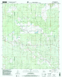 1998 Beaver2002 Print · USGSThe Allen and Evangeline Parish line runs through this piney woods landscape at the end of the nineties, just east of Oakdale. Local researchers can trace family landmarks like Beaver Cemetery or locate the Beaver Lookout Tower and Leger Landing Strip.2 unique versions available
 - 1998 Map of Oakdale, 2003 Print
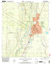 1998 Oakdale2003 Print · USGSOakdale and the surrounding Allen Parish wetlands are documented here in the late 1990s as the community balanced industrial growth with wildlife conservation. Researchers can trace family sites at Cryer Cem and Oak Hill Ch or follow the Old Railroad Grade through the woods.
End of results
Showing maps 1-2 of 2
Top cities near Oakdale
- Mamou historical maps
- Oberlin historical maps
- Glenmora historical maps
- Pine Prairie historical maps
- Elizabeth historical maps
- Forest Hill historical maps
See more
Frequently asked questions
- What are the different types of historical maps available for Oakdale?
- What is the oldest map of Oakdale?
- Where can I purchase historical maps of Oakdale for my home or office?
- Where can I download high-res historical maps of Oakdale?
- Are there historical topographic maps available for Oakdale?
- Is there historical aerial imagery available for Oakdale?
- Where are historical maps of Oakdale sourced from?