1930s Maps of Assumption Parish, Louisiana
Explore 7 historic maps of Assumption Parish from the 1930s. These maps offer a rare glimpse into what life looked like during the 1930s — showing old roads, neighborhoods, homes, and landmarks that have changed or disappeared over time.
Whether you're researching your family's past, planning a metal detecting trip, or studying how Assumption Parish's landscape evolved across the 1930s, these high-resolution maps are a powerful tool for exploring the history of this region.
- Focus on a specific era: All maps on this page are from the 1930s, giving you a focused view of this time period.
- See what’s changed: Compare century-old streets, trails, and buildings to today's modern landscape using overlays and satellite layers.
- Research with precision: Use these maps for genealogy, historical research, land use analysis, or educational projects.
- View, download, or print: Maps are fully viewable online in high resolution, and can be downloaded or printed for your own records.
Start exploring Assumption Parish's history through authentic maps from the 1930s. This is your window into the past.
Assumption Parish, LA maps
(7)- 1932 Map of Thibodaux SW
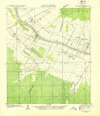 1932 Thibodaux SW1932 Print · USGSBayou Lafourche during the early thirties is a landscape of expansive sugar estates and bustling rail lines. Genealogists can locate family lands and landmarks like Labadieville, Cedar Grove Plantation, and the Brule Guillot Sch.
 - 1935 Map of Morgan City
 1935 Morgan City1935 Print · USGSIn the mid-thirties, the Atchafalaya delta was a vital crossroads of the Old Spanish Trail and Southern Pacific rail lines. Genealogists and historians can trace family locations from Fairview Plantation to the Bradley Family Cem and the Bayou Black Settlement.
 - 1935 Map of Chicot Lake, 1938 Print
 1935 Chicot Lake1938 Print · USGSInland Iberville Parish in the 1930s reveals a complex delta landscape managed by the Corps of Engineers. Researchers can trace the river-bound economy of the era through the Jack Miller Store, the Indian Mound, and the dredging of the Logging Canal.
 - 1936 Map of White Castle, 1937 Print
 1936 White Castle1937 Print · USGSThe Mississippi River corridor and its sprawling plantation estates are captured here in the mid-1930s. Researchers can trace family roots at Pierre Part Settlement or locate landmarks like the Leper Colony and St Marys Ch & Cem.2 unique versions available
 - 1938 Map of Labadieville
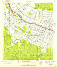 1938 Labadieville1938 Print · USGSAssumption Parish at the end of the Depression era remains a landscape of sprawling cane plantations and active bayou commerce. Genealogists and historians can trace family locations from Labadieville to rural outposts like Brule Guillot and New Belmont Ch.
 - 1939 Map of Donaldsonville, 1953 Print
 1939 Donaldsonville1953 Print · USGSLouisiana's river parishes are captured here in the late 1930s, showing a landscape defined by the winding Mississippi River and its rich agricultural traditions. Genealogists and historians can trace family roots through numerous combined school and church sites like Little Zion Sch Ch & Cem or the sprawling riverside Monroe Plantation.5 unique versions available
 - 1939 Map of Gibson, 1956 Print
 1939 Gibson1956 Print · USGSCoastal Louisiana at the end of the thirties was a world of rail-side settlements and bayou-based commerce. You can trace the lineage of small parish communities through Beattieville Gray P O, Mt Pilgrim Ch, and the Halfway Cem.
End of results
Showing maps 1-7 of 7
Top cities of Assumption Parish
Frequently asked questions
- What are the different types of historical maps available for Assumption Parish?
- What is the oldest map of Assumption Parish?
- Where can I purchase historical maps of Assumption Parish for my home or office?
- Where can I download high-res historical maps of Assumption Parish?
- Are there historical topographic maps available for Assumption Parish?
- Is there historical aerial imagery available for Assumption Parish?
- Where are historical maps of Assumption Parish sourced from?