1940s Maps of Assumption Parish, Louisiana
Explore 6 historic maps of Assumption Parish from the 1940s. These maps offer a rare glimpse into what life looked like during the 1940s — showing old roads, neighborhoods, homes, and landmarks that have changed or disappeared over time.
Whether you're researching your family's past, planning a metal detecting trip, or studying how Assumption Parish's landscape evolved across the 1940s, these high-resolution maps are a powerful tool for exploring the history of this region.
- Focus on a specific era: All maps on this page are from the 1940s, giving you a focused view of this time period.
- See what’s changed: Compare century-old streets, trails, and buildings to today's modern landscape using overlays and satellite layers.
- Research with precision: Use these maps for genealogy, historical research, land use analysis, or educational projects.
- View, download, or print: Maps are fully viewable online in high resolution, and can be downloaded or printed for your own records.
Start exploring Assumption Parish's history through authentic maps from the 1940s. This is your window into the past.
Assumption Parish, LA maps
(6)- 1940 Map of Madewood
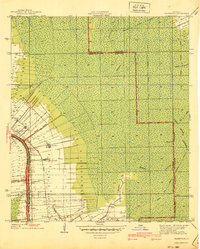 1940 Madewood1940 Print · USGSAssumption Parish at the end of the 1930s shows a landscape defined by the sugar economy and the wetlands. Genealogists and historians can trace family locations along Bayou Lafourche through old settlements like Madewood, Albemarle, and Aurelia.2 unique versions available
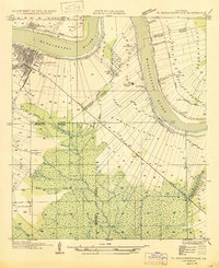
 - 1941 Map of Gibson
 1941 Gibson1941 Print · USGSCajun country and the sugarcane belt are mapped here just before the war, showing the rail-and-water corridors of the southern parishes. Genealogists can trace family names and local landmarks through sites like Beattleville Gray P O, Bull Run Sch, and Halfway Cem.
 - 1944 Map of Gibson
 1944 Gibson1944 Print · USGSCoastal Louisiana during the mid-forties reveals a landscape defined by delta bayous and early industrial rail lines. Genealogists can locate family landmarks like Mt Pilgrim Ch, St Johns Ch, and the Beattieville Gray PO.
 - 1945 Map of New Orleans
 1945 New Orleans1945 Print · USGSCoastal Louisiana and the Mississippi delta are captured here just after the war, showing the region's transition into a modern industrial and transit hub. Genealogists can trace family settlements along Bayou Teche or identify rail stops for the Illinois Central and Texas & Pacific lines.
 - 1947 Map of Donaldsonville
 1947 Donaldsonville1947 Print · USGSThe Mississippi River corridor near Donaldsonville comes to life in this mid-century survey of the river's winding path and industrial shoreline. Researchers can trace the rail lines of the Texas and Pacific, find the Saulsberg Refinery, and locate rural landmarks like the Brulie Maurin Sch.
 - 1948 Map of Foster, 1951 Print
 1948 Foster1951 Print · USGSSt. Martin and St. Mary Parishes are shown at a post-war turning point, where Bayou Teche's plantation heritage meets the industrial era. Family historians can locate specific sites like Verdunville, Butler Ch & Cem, and the river-based community at Irish Bend.
End of results
Showing maps 1-6 of 6
Top cities of Assumption Parish
Frequently asked questions
- What are the different types of historical maps available for Assumption Parish?
- What is the oldest map of Assumption Parish?
- Where can I purchase historical maps of Assumption Parish for my home or office?
- Where can I download high-res historical maps of Assumption Parish?
- Are there historical topographic maps available for Assumption Parish?
- Is there historical aerial imagery available for Assumption Parish?
- Where are historical maps of Assumption Parish sourced from?