1970s Maps of Belcher, Louisiana
Explore 2 historic maps of Belcher from the 1970s. These maps offer a rare glimpse into what life looked like during the 1970s — showing old roads, neighborhoods, homes, and landmarks that have changed or disappeared over time.
Whether you're researching your family's past, planning a metal detecting trip, or studying how Belcher's landscape evolved across the 1970s, these high-resolution maps are a powerful tool for exploring the history of this region.
- Focus on a specific era: All maps on this page are from the 1970s, giving you a focused view of this time period.
- See what’s changed: Compare century-old streets, trails, and buildings to today's modern landscape using overlays and satellite layers.
- Research with precision: Use these maps for genealogy, historical research, land use analysis, or educational projects.
- View, download, or print: Maps are fully viewable online in high resolution, and can be downloaded or printed for your own records.
Start exploring Belcher's history through authentic maps from the 1970s. This is your window into the past.
Belcher, LA maps
(2)- 1971 Map of Gilliam, 1973 Print
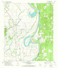 1971 Gilliam1973 Print · USGSThe Red River valley in the early 1970s shows a landscape of deep-rooted rural communities and heavy industry. Genealogists and historians can trace numerous country churches like St Elmo Ch and Union Chapel or locate the TEXAS AND PACIFIC rail stops at Cavett and Belcher.
 - 1971 Map of Vivian, 1974 Print
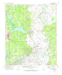 1971 Vivian1974 Print · USGSCaddo Parish at the start of the 1970s shows a landscape transformed by the energy industry and an intricate network of bayous. Researchers can trace family sites at Centerville Cem and Antioch Ch or explore the rail hubs of Vivian and Oil City.2 unique versions available
End of results
Showing maps 1-2 of 2
Top cities near Belcher
- Shreveport historical maps
- Bossier City historical maps
- Vivian historical maps
- Blanchard historical maps
- Benton historical maps
- Oil City historical maps
See more
Frequently asked questions
- What are the different types of historical maps available for Belcher?
- What is the oldest map of Belcher?
- Where can I purchase historical maps of Belcher for my home or office?
- Where can I download high-res historical maps of Belcher?
- Are there historical topographic maps available for Belcher?
- Is there historical aerial imagery available for Belcher?
- Where are historical maps of Belcher sourced from?