1990s Maps of Big Woods, Louisiana
Explore 1 historic maps of Big Woods from the 1990s. These maps offer a rare glimpse into what life looked like during the 1990s — showing old roads, neighborhoods, homes, and landmarks that have changed or disappeared over time.
Whether you're researching your family's past, planning a metal detecting trip, or studying how Big Woods's landscape evolved across the 1990s, these high-resolution maps are a powerful tool for exploring the history of this region.
- Focus on a specific era: All maps on this page are from the 1990s, giving you a focused view of this time period.
- See what’s changed: Compare century-old streets, trails, and buildings to today's modern landscape using overlays and satellite layers.
- Research with precision: Use these maps for genealogy, historical research, land use analysis, or educational projects.
- View, download, or print: Maps are fully viewable online in high resolution, and can be downloaded or printed for your own records.
Start exploring Big Woods's history through authentic maps from the 1990s. This is your window into the past.
Big Woods, LA maps
(1)- 1994 Map of Lunita, 1996 Print
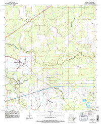 1994 Lunita1996 Print · USGSCalcasieu Parish in the mid-nineties shows a landscape defined by significant water engineering and small rural settlements. Genealogists and local historians can locate Big Woods Cem and Benevolent Cem, or trace the massive SABINE RIVER DIVERSION SYSTEM and the course of the Houston River.
End of results
Showing maps 1-1 of 1
Top cities near Big Woods
- Sulphur historical maps
- Orange historical maps
- Bridge City historical maps
- West Orange historical maps
- Vinton historical maps
- DeQuincy historical maps
See more
Frequently asked questions
- What are the different types of historical maps available for Big Woods?
- What is the oldest map of Big Woods?
- Where can I purchase historical maps of Big Woods for my home or office?
- Where can I download high-res historical maps of Big Woods?
- Are there historical topographic maps available for Big Woods?
- Is there historical aerial imagery available for Big Woods?
- Where are historical maps of Big Woods sourced from?