1900s (20th Century) Maps of Hecker, Louisiana
Explore 8 historic maps of Hecker from the 1900s (20th Century). These maps offer a rare glimpse into what life looked like during the 1900s — showing old roads, neighborhoods, homes, and landmarks that have changed or disappeared over time.
Whether you're researching your family's past, planning a metal detecting trip, or studying how Hecker's landscape evolved across the 1900s, these high-resolution maps are a powerful tool for exploring the history of this region.
- Focus on a specific era: All maps on this page are from the 1900s, giving you a focused view of this time period.
- See what’s changed: Compare century-old streets, trails, and buildings to today's modern landscape using overlays and satellite layers.
- Research with precision: Use these maps for genealogy, historical research, land use analysis, or educational projects.
- View, download, or print: Maps are fully viewable online in high resolution, and can be downloaded or printed for your own records.
Start exploring Hecker's history through authentic maps from the 1900s. This is your window into the past.
Hecker, LA maps
(8)- 1947 Map of Hecker
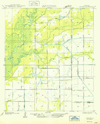
 1947 Hecker1947 Print · USGSCalcasieu Parish was undergoing a significant transition between the world wars as timber harvesting and irrigation-based farming shaped the land. Researchers can trace the path of the Logging Railroad and locate family homes near Hecker and Stackpole.
 - 1950 Map of Hecker
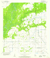
 1950 Hecker1950 Print · USGSSouthwestern Louisiana's wetlands and early agricultural infrastructure are visible here in the years following the mid-1930s field surveys. Trace the Old Logging Railroad Grade and the engineering of the Louisiana Irrigation Canal near Hecker.
 - 1952 Map of Lake Charles
 1952 Lake Charles1952 Print · USGSSouthwest Louisiana is captured here in the mid-fifties, showing a landscape defined by the rise of the petrochemical industry and deep-water navigation. Researchers can trace family roots through numerous small-town settlements and oil developments like Nibletts Bluff, the Lockport Oil Field, and Starks.
 - 1954 Map of Lake Charles, 1964 Print
 1954 Lake Charles1964 Print · USGSSouthwest Louisiana in the mid-fifties is defined by its massive petroleum industry and its complex network of bayous and rail lines. Researchers can trace the development of the Sulphur Mines Oil Field or locate historic settlements like Longville and De Quincy.3 unique versions available
 - 1956 Map of Hecker, 1957 Print
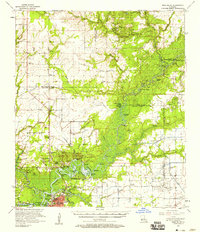
 1956 Hecker1957 Print · USGSCalcasieu Parish in the mid-1950s shows a landscape defined by the Iowa Oil and Gas Field and a complex irrigation network. Genealogists and historians can locate family landmarks like Hebert Cem and the settlements of Hecker and Le Bleu.3 unique versions available
 - 1957 Map of Moss Bluff, 1958 Print
 1957 Moss Bluff1958 Print · USGSCalcasieu Parish and its surrounding bayous are captured here in the late fifties as the river economy transitions toward industry. Researchers can trace family roots at Birdnest Cem or locate historic river crossings like Perkins Ferry.3 unique versions available
 - 1986 Map of Lake Charles
 1986 Lake Charles1986 Print · USGSThe Louisiana-Texas borderlands are captured here in the mid-1980s, showcasing the industrial growth of the Lake Charles region and its rail-linked satellite towns. Trace the evolution of coastal settlements and family landmarks from Sulphur to the Highland Cem.2 unique versions available
 - 1994 Map of Hecker, 1996 Print
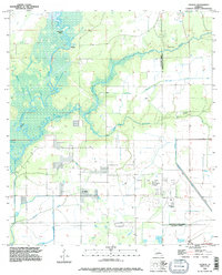 1994 Hecker1996 Print · USGSCalcasieu and Jefferson Davis Parishes are shown in the mid-1990s, revealing a landscape defined by industrial oil fields and deep-rooted bayou settlements. Local researchers can trace family landmarks like Hebert Cem and La France Cem or explore the wetlands surrounding Hecker and the Iowa Oil and Gas Field.
End of results
Showing maps 1-8 of 8
Top cities near Hecker
- Lake Charles historical maps
- Sulphur historical maps
- Westlake historical maps
- Iowa historical maps
- Kinder historical maps
- Fenton historical maps
See more
Frequently asked questions
- What are the different types of historical maps available for Hecker?
- What is the oldest map of Hecker?
- Where can I purchase historical maps of Hecker for my home or office?
- Where can I download high-res historical maps of Hecker?
- Are there historical topographic maps available for Hecker?
- Is there historical aerial imagery available for Hecker?
- Where are historical maps of Hecker sourced from?