1930s Maps of Johnsons Bayou, Louisiana
Explore 2 historic maps of Johnsons Bayou from the 1930s. These maps offer a rare glimpse into what life looked like during the 1930s — showing old roads, neighborhoods, homes, and landmarks that have changed or disappeared over time.
Whether you're researching your family's past, planning a metal detecting trip, or studying how Johnsons Bayou's landscape evolved across the 1930s, these high-resolution maps are a powerful tool for exploring the history of this region.
- Focus on a specific era: All maps on this page are from the 1930s, giving you a focused view of this time period.
- See what’s changed: Compare century-old streets, trails, and buildings to today's modern landscape using overlays and satellite layers.
- Research with precision: Use these maps for genealogy, historical research, land use analysis, or educational projects.
- View, download, or print: Maps are fully viewable online in high resolution, and can be downloaded or printed for your own records.
Start exploring Johnsons Bayou's history through authentic maps from the 1930s. This is your window into the past.
Johnsons Bayou, LA maps
(2)- 1934 Map of Johnsons Bayou, 1955 Print
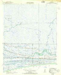 1934 Johnsons Bayou1955 Print · USGSCameron Parish's coastal ridge settlements are captured here in the mid-1930s, showing the intersection of local community life and the marshy Gulf landscape. Researchers can locate the Johnsons Bayou School, the Pevoto Cemetery, and the local post office.3 unique versions available
 - 1935 Map of Johnsons Bayou
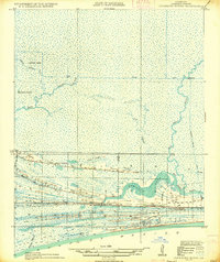 1935 Johnsons Bayou1935 Print · USGSThe marshy coastline of Cameron Parish in the mid-1930s reveals a community built atop thin ribbons of higher ground. Genealogists and local researchers can locate family sites along Smith Ridge, including the Johnsons Bayou PO and Peveto Cemetery.2 unique versions available
End of results
Showing maps 1-2 of 2
Top cities near Johnsons Bayou
Frequently asked questions
- What are the different types of historical maps available for Johnsons Bayou?
- What is the oldest map of Johnsons Bayou?
- Where can I purchase historical maps of Johnsons Bayou for my home or office?
- Where can I download high-res historical maps of Johnsons Bayou?
- Are there historical topographic maps available for Johnsons Bayou?
- Is there historical aerial imagery available for Johnsons Bayou?
- Where are historical maps of Johnsons Bayou sourced from?