
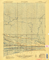
1935 Map of Johnsons Bayou
USGS Topo · Published 1935About this map
Junius Ridge and Hamilton Ridge rise slightly above the sprawling marshlands of the Cameron Parish coast, providing the essential dry ground for settlement along the Gulf of Mexico. This 1934 survey, compiled in part from Air Corps aerial photographs, reveals a landscape defined by an intricate network of waterways like Deep Bayou, Hog Gully, and Starks Canal. Human activity is concentrated along the east-west elevations of Smith Ridge, where the local community center is anchored by the Johnsons Bayou PO, the Johnsons Bayou School, and the Peveto Cemetery. The mapping of the Magnolia-Vacuum Canal suggests the early industrial influence of drainage or petroleum exploration on this low-lying coastal prairie. This survey captures a specific moment in the geography of the southwestern Louisiana coast before later twentieth-century coastal erosion and canal dredging further altered the bayou system.
Find a feature on this map
21 named features on this map. Tap any name to fly to it.
Don’t see what you’re looking for? This feature index may not catch every label — zoom into the map to look around manually.
Map Details
Editions of this 1935 Johnsons Bayou Map
2 editions found
Other maps of this area

1932 · Sabine Pass NE
USGS Topo · 1:31,680

1932 · Port Arthur NE
USGS Topo · 1:31,680

1934 · Johnsons Bayou
USGS Topo · 1:24,000

1934 · Peveto Beach
USGS Topo · 1:24,000

1934 · Greens Bayou
USGS Topo · 1:24,000

1934 · Five Lakes
USGS Topo · 1:24,000

1935 · Peveto Beach
USGS Topo · 1:31,680

1935 · Five Lakes
USGS Topo · 1:31,680

1935 · Greens Bayou
USGS Topo · 1:31,680

1943 · West of Johnson Bayou
USGS Topo · 1:24,000