1990s Maps of Baker, Louisiana
Explore 2 historic maps of Baker from the 1990s. These maps offer a rare glimpse into what life looked like during the 1990s — showing old roads, neighborhoods, homes, and landmarks that have changed or disappeared over time.
Whether you're researching your family's past, planning a metal detecting trip, or studying how Baker's landscape evolved across the 1990s, these high-resolution maps are a powerful tool for exploring the history of this region.
- Focus on a specific era: All maps on this page are from the 1990s, giving you a focused view of this time period.
- See what’s changed: Compare century-old streets, trails, and buildings to today's modern landscape using overlays and satellite layers.
- Research with precision: Use these maps for genealogy, historical research, land use analysis, or educational projects.
- View, download, or print: Maps are fully viewable online in high resolution, and can be downloaded or printed for your own records.
Start exploring Baker's history through authentic maps from the 1990s. This is your window into the past.
Baker, LA maps
(2)- 1995 Map of Scotlandville, 1998 Print
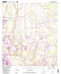
 1995 Scotlandville1998 Print · USGSEast Baton Rouge Parish is seen in the mid-nineties as the industrial and academic corridor north of the city continued to expand. Researchers can locate the historic campus of Southern University, the State Industrial School for Boys, and family sites at Banks Cem.
 - 1996 Map of Comite, 1999 Print
 1996 Comite1999 Print · USGSNorth of Baton Rouge in the mid-1990s, the rural bayou landscape was rapidly transforming into a suburban corridor. Researchers can trace family sites like Edwards Cem, old country churches like Zoar Ch, and the grounds of Camp Yola Kehn.
End of results
Showing maps 1-2 of 2
Top cities near Baker
- Baton Rouge historical maps
- Saint George historical maps
- St. George historical maps
- Central historical maps
- Zachary historical maps
- Denham Springs historical maps
See more
Top neighborhoods of Baker
- Parkridge historical maps
- Baker Estates historical maps
- Bethany Cooperative Community historical maps
- Buffwood historical maps
- Feliciana historical maps
- Baker Hills historical maps
See more
Frequently asked questions
- What are the different types of historical maps available for Baker?
- What is the oldest map of Baker?
- Where can I purchase historical maps of Baker for my home or office?
- Where can I download high-res historical maps of Baker?
- Are there historical topographic maps available for Baker?
- Is there historical aerial imagery available for Baker?
- Where are historical maps of Baker sourced from?