1960s Maps of Zachary, Louisiana
Explore 6 historic maps of Zachary from the 1960s. These maps offer a rare glimpse into what life looked like during the 1960s — showing old roads, neighborhoods, homes, and landmarks that have changed or disappeared over time.
Whether you're researching your family's past, planning a metal detecting trip, or studying how Zachary's landscape evolved across the 1960s, these high-resolution maps are a powerful tool for exploring the history of this region.
- Focus on a specific era: All maps on this page are from the 1960s, giving you a focused view of this time period.
- See what’s changed: Compare century-old streets, trails, and buildings to today's modern landscape using overlays and satellite layers.
- Research with precision: Use these maps for genealogy, historical research, land use analysis, or educational projects.
- View, download, or print: Maps are fully viewable online in high resolution, and can be downloaded or printed for your own records.
Start exploring Zachary's history through authentic maps from the 1960s. This is your window into the past.
Zachary, LA maps
(6)- 1961 Map of Baton Rouge, 1966 Print
 1961 Baton Rouge1966 Print · USGSSoutheastern Louisiana in the early sixties remains a landscape of deep river bends and sprawling coastal lakes. Genealogists and historians can trace the rail-and-river economy through landmarks like Free-Nigger Point, Donaldsonville, and the Illinois Central Railroad.
 - 1962 Map of Baton Rouge
 1962 Baton Rouge1962 Print · USGSSouth Louisiana in the early sixties reveals a landscape of river-bend parishes and emerging interstate corridors. Genealogists and historians can trace family roots through historic river towns like Donaldsonville and Plaquemine, or follow the path of the Illinois Central Railroad through the swamp basins.
 - 1963 Map of Scotlandville, 1964 Print
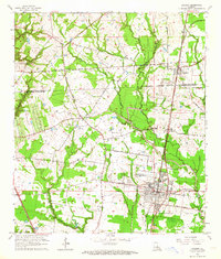
 1963 Scotlandville1964 Print · USGSThe northern reaches of Baton Rouge during the early sixties show a landscape balancing institutional growth with the industrial riverfront. Researchers can trace the footprints of Southern University, Leland College, and local landmarks like Free Negro Point.5 unique versions available
 - 1963 Map of Fred, 1964 Print
 1963 Fred1964 Print · USGSLouisiana's upland parish country comes alive in this early 1960s survey of the wooded drainages north of Baton Rouge. Genealogists can trace family names and rural congregations at Strangers Home Ch, Black Cem, and the crossroads of Milldale.3 unique versions available
 - 1963 Map of Zachary, 1964 Print
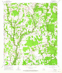
 1963 Zachary1964 Print · USGSEast Baton Rouge and East Feliciana parishes are captured here in the early sixties as rural life meets new industrial growth. Genealogists and local historians can trace family locations through Stanford Cem, Ebenezer Ch, and the streets of Zachary.4 unique versions available
 - 1963 Map of Zachary, 1967 Print
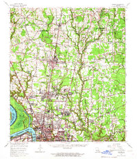 1963 Zachary1967 Print · USGSThe northern corridor of East Baton Rouge Parish shows a blend of river industry and growing suburban centers in the early sixties. Genealogists can locate dozens of church-linked burial sites like Azalea Rest Cem and schools such as Leland College or Southern University.2 unique versions available
End of results
Showing maps 1-6 of 6
Top cities near Zachary
- Baton Rouge historical maps
- St. George historical maps
- Central historical maps
- Baker historical maps
- Denham Springs historical maps
- Port Allen historical maps
See more
Top neighborhoods of Zachary
Frequently asked questions
- What are the different types of historical maps available for Zachary?
- What is the oldest map of Zachary?
- Where can I purchase historical maps of Zachary for my home or office?
- Where can I download high-res historical maps of Zachary?
- Are there historical topographic maps available for Zachary?
- Is there historical aerial imagery available for Zachary?
- Where are historical maps of Zachary sourced from?