1910s Maps of East Carroll Parish, Louisiana
Explore 5 historic maps of East Carroll Parish from the 1910s. These maps offer a rare glimpse into what life looked like during the 1910s — showing old roads, neighborhoods, homes, and landmarks that have changed or disappeared over time.
Whether you're researching your family's past, planning a metal detecting trip, or studying how East Carroll Parish's landscape evolved across the 1910s, these high-resolution maps are a powerful tool for exploring the history of this region.
- Focus on a specific era: All maps on this page are from the 1910s, giving you a focused view of this time period.
- See what’s changed: Compare century-old streets, trails, and buildings to today's modern landscape using overlays and satellite layers.
- Research with precision: Use these maps for genealogy, historical research, land use analysis, or educational projects.
- View, download, or print: Maps are fully viewable online in high resolution, and can be downloaded or printed for your own records.
Start exploring East Carroll Parish's history through authentic maps from the 1910s. This is your window into the past.
East Carroll Parish, LA maps
(5)- 1911 Map of Lake Providence
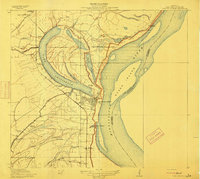 1911 Lake Providence1911 Print · USGSLouisiana's Mississippi River delta region comes into sharp focus during the early 1910s, centered on the strategic oxbow lake at the parish seat. Genealogists and historians can trace family landholdings at Belle Mead Plantation or locate local landmarks like Winterfield School and Cane Ridge Church.2 unique versions available
 - 1911 Map of Baxter Bayou, 1961 Print
 1911 Baxter Bayou1961 Print · USGSLouisiana's Mississippi Delta region appears as a network of winding waterways and large agricultural estates just after the turn of the century. Trace the boundaries of Tompkins Plantation, find the Lickskillet School, or locate the abandoned Corbins Ferry along Macon Bayou.
 - 1912 Map of Ashton Bridge
 1912 Ashton Bridge1912 Print · USGSNortheast Louisiana timber and transit are captured here in the years before the Great War. Researchers can trace the industrial footprint of Cook and McLean's Sawmill and the early Tram Road crossing Bayou Macon.3 unique versions available
 - 1913 Map of Wilson Point
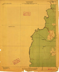
 1913 Wilson Point1913 Print · USGSEast Carroll Parish at the height of the levee-building era shows a landscape defined by the shifting banks of the Mississippi River. Researchers can trace the riverfront settlements at Wilson Point and Cottonwood, or locate the Morning Star Church near the water.
 - 1914 Map of Baxter Bayou
 1914 Baxter Bayou1914 Print · USGSEast Carroll Parish in the early twentieth century is a landscape of expansive plantations and winding delta waterways. Family historians can trace ancestral lands at Tompkins Plantation or Bowie Plantation, and locate rural landmarks like Lickskillet School.2 unique versions available
End of results
Showing maps 1-5 of 5
Top cities of East Carroll Parish
Frequently asked questions
- What are the different types of historical maps available for East Carroll Parish?
- What is the oldest map of East Carroll Parish?
- Where can I purchase historical maps of East Carroll Parish for my home or office?
- Where can I download high-res historical maps of East Carroll Parish?
- Are there historical topographic maps available for East Carroll Parish?
- Is there historical aerial imagery available for East Carroll Parish?
- Where are historical maps of East Carroll Parish sourced from?