1900-1909 Maps of East Carroll Parish, Louisiana
Explore 5 historic maps of East Carroll Parish from 1900-1909. These maps offer a rare glimpse into what life looked like during the 1900s — showing old roads, neighborhoods, homes, and landmarks that have changed or disappeared over time.
Whether you're researching your family's past, planning a metal detecting trip, or studying how East Carroll Parish's landscape evolved across the 1900s, these high-resolution maps are a powerful tool for exploring the history of this region.
- Focus on a specific era: All maps on this page are from the 1900s, giving you a focused view of this time period.
- See what’s changed: Compare century-old streets, trails, and buildings to today's modern landscape using overlays and satellite layers.
- Research with precision: Use these maps for genealogy, historical research, land use analysis, or educational projects.
- View, download, or print: Maps are fully viewable online in high resolution, and can be downloaded or printed for your own records.
Start exploring East Carroll Parish's history through authentic maps from the 1900s. This is your window into the past.
East Carroll Parish, LA maps
(5)- 1909 Map of Baxter Bayou
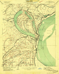
 1909 Baxter Bayou1909 Print · USGSLouisiana's delta country at the end of the first decade of the twentieth century shows a landscape tied to its winding waterways. Researchers can locate early river crossings and oxbows like Lanes Ferry Bridge, Corbins Ferry (Abandoned), and Johnson Lake.
 - 1909 Map of Lake Providence
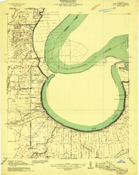
 1909 Lake Providence1909 Print · USGSEast Carroll Parish at the turn of the century shows a landscape of expansive plantations and river commerce centered on the great oxbow. Genealogists and historians can locate family estates like Way Way Plantation or trace community roots at Good Hope Church and Watersheta School.2 unique versions available
 - 1909 Map of Wilsons Point
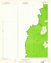
 1909 Wilsons Point1909 Print · USGSEast Carroll Parish at the height of the river trade era reveals a landscape of alluvial points and levee-protected settlements. Genealogists and researchers can trace land tracts near Wilsons Point, the Morning Star Church, and the riverfront at Cottonwood.2 unique versions available
 - 1909 Map of Millikin
 1909 Millikin1909 Print · USGSEast Carroll Parish at the turn of the century reveals a landscape of large riverside estates and early rail infrastructure. Researchers can trace family history through sites like Ashton Plantation, find old commercial hubs like the Bells of the Bend Store, or locate vanished landmarks like Millikin School.2 unique versions available
 - 1909 Map of Ashton Bridge, 1961 Print
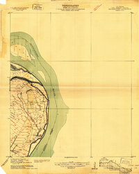
 1909 Ashton Bridge1961 Print · USGSThe Louisiana delta country at the turn of the century is documented here along the winding Bayou Macon. Researchers can trace early industry and transport through Cook and McLean's Sawmill, a Tram Road, and the original Ashton Bridge.
End of results
Showing maps 1-5 of 5
Top cities of East Carroll Parish
Frequently asked questions
- What are the different types of historical maps available for East Carroll Parish?
- What is the oldest map of East Carroll Parish?
- Where can I purchase historical maps of East Carroll Parish for my home or office?
- Where can I download high-res historical maps of East Carroll Parish?
- Are there historical topographic maps available for East Carroll Parish?
- Is there historical aerial imagery available for East Carroll Parish?
- Where are historical maps of East Carroll Parish sourced from?