1980s Maps of Wilson, Louisiana
Explore 3 historic maps of Wilson from the 1980s. These maps offer a rare glimpse into what life looked like during the 1980s — showing old roads, neighborhoods, homes, and landmarks that have changed or disappeared over time.
Whether you're researching your family's past, planning a metal detecting trip, or studying how Wilson's landscape evolved across the 1980s, these high-resolution maps are a powerful tool for exploring the history of this region.
- Focus on a specific era: All maps on this page are from the 1980s, giving you a focused view of this time period.
- See what’s changed: Compare century-old streets, trails, and buildings to today's modern landscape using overlays and satellite layers.
- Research with precision: Use these maps for genealogy, historical research, land use analysis, or educational projects.
- View, download, or print: Maps are fully viewable online in high resolution, and can be downloaded or printed for your own records.
Start exploring Wilson's history through authentic maps from the 1980s. This is your window into the past.
Wilson, LA maps
(3)- 1983 Map of New Roads
 1983 New Roads1983 Print · USGSThe river parishes of central Louisiana are documented in the early 1980s, showcasing the winding courses of the Atchafalaya and Mississippi. Genealogists and historians can trace rail-served river towns like Melville and Simmesport, or locate the Port Hudson National Cem and the State Penitentiary.2 unique versions available
 - 1984 Map of Rogillioville, 1985 Print
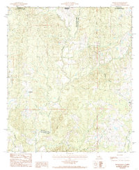 1984 Rogillioville1985 Print · USGSThe Louisiana-Mississippi borderlands come alive in this mid-1980s survey, showing the deep creek bottoms and rail-linked towns of the Felicianas. Genealogists can trace family landmarks and burial sites like Rogillioville, Wilson, and local Cem locations.
 - 1985 Map of Wilson
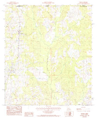 1985 Wilson1985 Print · USGSEast Feliciana Parish in the mid-1980s shows a landscape of rural settlements and winding bayous along the Mississippi border. Genealogists and historians can trace the Illinois Central Gulf rail line as it passes through Norwood and Wilson.
End of results
Showing maps 1-3 of 3
Top cities near Wilson
- Zachary historical maps
- Jackson historical maps
- Clinton historical maps
- Centreville historical maps
- Slaughter historical maps
- Woodville historical maps
See more
Frequently asked questions
- What are the different types of historical maps available for Wilson?
- What is the oldest map of Wilson?
- Where can I purchase historical maps of Wilson for my home or office?
- Where can I download high-res historical maps of Wilson?
- Are there historical topographic maps available for Wilson?
- Is there historical aerial imagery available for Wilson?
- Where are historical maps of Wilson sourced from?