1930s Maps of Evangeline Parish, Louisiana
Explore 4 historic maps of Evangeline Parish from the 1930s. These maps offer a rare glimpse into what life looked like during the 1930s — showing old roads, neighborhoods, homes, and landmarks that have changed or disappeared over time.
Whether you're researching your family's past, planning a metal detecting trip, or studying how Evangeline Parish's landscape evolved across the 1930s, these high-resolution maps are a powerful tool for exploring the history of this region.
- Focus on a specific era: All maps on this page are from the 1930s, giving you a focused view of this time period.
- See what’s changed: Compare century-old streets, trails, and buildings to today's modern landscape using overlays and satellite layers.
- Research with precision: Use these maps for genealogy, historical research, land use analysis, or educational projects.
- View, download, or print: Maps are fully viewable online in high resolution, and can be downloaded or printed for your own records.
Start exploring Evangeline Parish's history through authentic maps from the 1930s. This is your window into the past.
Evangeline Parish, LA maps
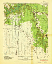
(4)- 1935 Map of Beaver
 1935 Beaver1935 Print · USGSEvangeline Parish is captured here during the mid-1930s as the era of heavy timber harvesting leaves its mark on the land. Researchers can trace the sprawling Old Logging Railroad Grade and locate old gathering places like Cypress Creek Settlement and the Beaver Sch.
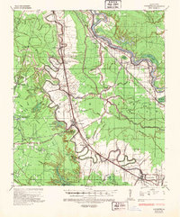
 - 1935 Map of Turkey Creek
 1935 Turkey Creek1935 Print · USGSLouisiana's central parish borderlands come alive in the mid-1930s, showing a landscape defined by meandering bayous and early industrial corridors. Trace the path of the Texas Louisiana and Gulf RR or find family landmarks like Johnson Ldg and Lake Cove Sch.
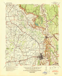
 - 1935 Map of Lecompte, 1949 Print
 1935 Lecompte1949 Print · USGSThe Red River valley south of Alexandria comes into focus in the mid-1930s, showing a landscape defined by meandering bayous and critical rail lines. Genealogists can locate family landmarks like Spring Hill Cem, St Johns Ch, and the town of Cheneyville.
 - 1939 Map of Opelousas, 1942 Print
 1939 Opelousas1942 Print · USGSSt. Landry Parish is revealed at a moment of industrial and agricultural transition in the late thirties. Researchers can trace family roots through numerous parish schools and churches, including Gradney Island Sch, Mohin Ch & Cem, and the Wartell Plantation.2 unique versions available
End of results
Showing maps 1-4 of 4
Top cities of Evangeline Parish
- Ville Platte historical maps
- Mamou historical maps
- Basile historical maps
- Pine Prairie historical maps
- Chataignier historical maps
- Turkey Creek historical maps
Frequently asked questions
- What are the different types of historical maps available for Evangeline Parish?
- What is the oldest map of Evangeline Parish?
- Where can I purchase historical maps of Evangeline Parish for my home or office?
- Where can I download high-res historical maps of Evangeline Parish?
- Are there historical topographic maps available for Evangeline Parish?
- Is there historical aerial imagery available for Evangeline Parish?
- Where are historical maps of Evangeline Parish sourced from?