Old Maps of Evangeline Parish, Louisiana for Genealogy
Trace your family roots with 161 historic maps of Evangeline Parish. These high-res maps reveal old neighborhoods, homesites, landmarks, and streets — helping you uncover where your ancestors lived and how the area evolved over time.
- Explore historic neighborhoods: Identify where your relatives may have lived in the 1800s or 1900s.
- Compare maps over time: Trace the changes in streets, buildings, and landmarks for multi-generational research.
- Perfect for genealogy & ancestry research: Used by family historians and researchers to map out lineage and migration.
These maps are an incredible resource for exploring your personal connection to Evangeline Parish's past.
Evangeline Parish, LA maps
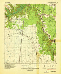
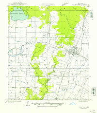
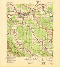
(161)- 1935 Map of Beaver
 1935 Beaver1935 Print · USGSEvangeline Parish is captured here during the mid-1930s as the era of heavy timber harvesting leaves its mark on the land. Researchers can trace the sprawling Old Logging Railroad Grade and locate old gathering places like Cypress Creek Settlement and the Beaver Sch.
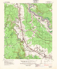
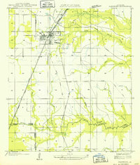
 - 1935 Map of Turkey Creek
 1935 Turkey Creek1935 Print · USGSLouisiana's central parish borderlands come alive in the mid-1930s, showing a landscape defined by meandering bayous and early industrial corridors. Trace the path of the Texas Louisiana and Gulf RR or find family landmarks like Johnson Ldg and Lake Cove Sch.
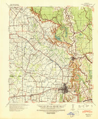
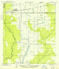
 - 1935 Map of Lecompte, 1949 Print
 1935 Lecompte1949 Print · USGSThe Red River valley south of Alexandria comes into focus in the mid-1930s, showing a landscape defined by meandering bayous and critical rail lines. Genealogists can locate family landmarks like Spring Hill Cem, St Johns Ch, and the town of Cheneyville.
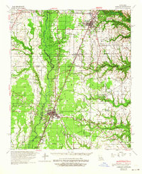
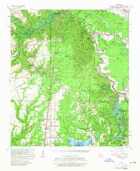
 - 1939 Map of Opelousas, 1942 Print
 1939 Opelousas1942 Print · USGSSt. Landry Parish is revealed at a moment of industrial and agricultural transition in the late thirties. Researchers can trace family roots through numerous parish schools and churches, including Gradney Island Sch, Mohin Ch & Cem, and the Wartell Plantation.2 unique versions available
 - 1942 Map of Oakdale, 1964 Print
 1942 Oakdale1964 Print · USGSCentral Louisiana's timber and rail country comes to life in the early 1940s as the Calcasieu River winds through Oakdale and Glenmora. Genealogists can trace family roots through landmarks like Hargrove Farm, Cryer Cem, and Cypress Creek Settlement.
 - 1947 Map of Ville Platte
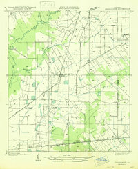
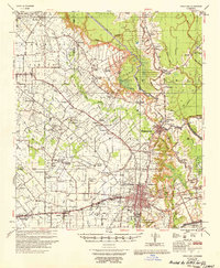
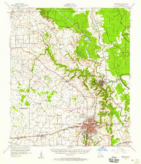
 1947 Ville Platte1947 Print · USGSEvangeline Parish at the end of the 1940s reveals a landscape of prairie farms and bayous centered on the railroad. Researchers can trace family-named landmarks and rural hubs like St. Thomas Ch, Point Blue, and the Thompson Sch near the Bayou des Cannes.
 - 1947 Map of Fruge Lake
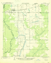
 1947 Fruge Lake1947 Print · USGSThe Louisiana bayou country during the mid-1930s reveals a transition from timber harvesting to rural settlement along the Allen and Evangeline Parish line. Genealogists and local historians can pinpoint family landmarks like Veillon Sch, Valentine Sch, and the Old Logging Railroad Grade.
 - 1947 Map of Redland
 1947 Redland1947 Print · USGSThe prairies of southern Louisiana come alive in this post-war map of the area around Eunice and the Bayou des Cannes. Researchers can trace old rail corridors like the Southern Pacific and locate rural landmarks such as Duralde Sch and Fenris.
 - 1947 Map of Chataignier
 1947 Chataignier1947 Print · USGSCoastal prairie life and Bayou country are captured here in the late Forties at the edge of the Evangeline and St. Landry Parish line. Genealogists can trace early homesteads and landmarks like St. Joseph Ch and Point Blue Sch along the Texas and Pacific rail line.
 - 1947 Map of Elton
 1947 Elton1947 Print · USGSJefferson Davis Parish was a landscape of rail-dependent farming communities in the late 1940s. Genealogists and local historians can locate rural landmarks such as China Cem, Fusilier Sch, and the small settlement of Wilburton.
 - 1947 Map of Bond
 1947 Bond1947 Print · USGSEvangeline and Allen Parishes are shown during the mid-1940s, highlighting a landscape transitioning from heavy timber production to rural agricultural life. Researchers can trace the Old Logging Railroad Grade and locate early schools like High Point Sch and Johnson Cove Sch.
 - 1947 Map of Eunice
 1947 Eunice1947 Print · USGSThe rail-and-bayou landscape of south Louisiana comes alive in the mid-1940s, centered on the growing town of Eunice. Local researchers can trace family roots through rural landmarks like Bozyone Sch and the smaller settlements of Mowata and Amy.
 - 1947 Map of Basile
 1947 Basile1947 Print · USGSBasile and the surrounding Louisiana prairie are captured here in the late 1940s as the region's agricultural and rail networks were fully established. Researchers can trace family sites near Reed Cem and St Monica Ch, or follow the industrial waterworks of the Mamou Canal.
 - 1948 Map of Bunkie, 1950 Print
 1948 Bunkie1950 Print · USGSThe Bunkie area during the late 1940s reveals a landscape defined by Bayou Boeuf and a dense network of early oil infrastructure. Genealogists can trace family roots through numerous rural landmarks like St Lukes Ch & Cem and the Goudeau Sch.
 - 1949 Map of Glenmora
 1949 Glenmora1949 Print · USGSCentral Louisiana's timber country comes to life in this mid-century survey of the Rapides Parish area. Genealogists and historians can trace the fading tracks of the Old Logging Railroad Grade and explore the early footprints of Glenmora and McNary.
 - 1949 Map of Basile
 1949 Basile1949 Print · USGSLouisiana's prairie and bayou country meet in the late 1940s at the junction of four different parishes. Researchers can trace the family landmarks of this agricultural landscape, from the Reed Cem and St Monica Ch to the remote Kaplan Pump Sta.
 - 1949 Map of Turkey Creek, 1965 Print
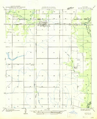
 1949 Turkey Creek1965 Print · USGSEvangeline Parish during the late 1940s reveals a rural landscape of bayous and rising industry. Trace family roots at Messer Settlement or Oak Grove Cem, and locate the old rail lines of the Rock Island RR.
 - 1952 Map of Lake Charles
 1952 Lake Charles1952 Print · USGSSouthwest Louisiana is captured here in the mid-fifties, showing a landscape defined by the rise of the petrochemical industry and deep-water navigation. Researchers can trace family roots through numerous small-town settlements and oil developments like Nibletts Bluff, the Lockport Oil Field, and Starks.
 - 1953 Map of Alexandria, 1963 Print
 1953 Alexandria1963 Print · USGSCentral Louisiana during the early fifties is mapped here at the intersection of the piney woods and the Red River valley. Genealogists and historians can trace the rail-and-river network connecting towns like Alexandria, Natchitoches, and the grounds of Camp Beauregard.3 unique versions available
 - 1954 Map of Beaver
 1954 Beaver1954 Print · USGSEvangeline and Allen Parish lands appear here in the mid-1930s, showing a landscape shaped by the waning days of the timber industry. Genealogists and historians can trace the foundations of the Cypress Creek Settlement, the Beaver School, and miles of Old Logging Railroad grades.
 - 1954 Map of Fruge Lake
 1954 Fruge Lake1954 Print · USGSEvangeline and Allen Parishes in the mid-1930s, as captured by this survey, show a landscape tied to its bayous and early timber heritage. Genealogists and historians can locate legacy sites like Fruge Sch and Valentine Sch or trace the Old Logging Railroad Grade.
 - 1954 Map of Lake Charles, 1964 Print
 1954 Lake Charles1964 Print · USGSSouthwest Louisiana in the mid-fifties is defined by its massive petroleum industry and its complex network of bayous and rail lines. Researchers can trace the development of the Sulphur Mines Oil Field or locate historic settlements like Longville and De Quincy.3 unique versions available
 - 1955 Map of Alexandria
 1955 Alexandria1955 Print · USGSCentral Louisiana in the mid-fifties is a landscape of river-port cities, sprawling timberlands, and massive military reservations. Genealogists and historians can trace the rail networks of the Texas & Pacific RR and locate sites like Camp Polk Military Reservation and Natchitoches.
 - 1956 Map of Opelousas
 1956 Opelousas1956 Print · USGSSt. Landry Parish in the mid-fifties shows a landscape of productive prairies and complex bayou engineering. Genealogists and historians can trace family locations through numerous rural landmarks like Sacred Heart Ch & Cem, Wartell Plantation, and Thistlewaite.
 - 1957 Map of Opelousas, 1958 Print
 1957 Opelousas1958 Print · USGSSt. Landry Parish in the late fifties showcases a landscape of bayous and railroads at the height of the local oil and gas boom. Genealogists and historians can trace family-named sites like Bertrand Cem, Chimleyville Ch, and the Academy of Immaculate Conception.2 unique versions available
Showing maps 1-25 of 161
Top cities of Evangeline Parish
- Ville Platte historical maps
- Mamou historical maps
- Basile historical maps
- Pine Prairie historical maps
- Chataignier historical maps
- Turkey Creek historical maps
Frequently asked questions
- What are the different types of historical maps available for Evangeline Parish?
- What is the oldest map of Evangeline Parish?
- Where can I purchase historical maps of Evangeline Parish for my home or office?
- Where can I download high-res historical maps of Evangeline Parish?
- Are there historical topographic maps available for Evangeline Parish?
- Is there historical aerial imagery available for Evangeline Parish?
- Where are historical maps of Evangeline Parish sourced from?