1990s Maps of Welsh, Louisiana
Explore 1 historic maps of Welsh from the 1990s. These maps offer a rare glimpse into what life looked like during the 1990s — showing old roads, neighborhoods, homes, and landmarks that have changed or disappeared over time.
Whether you're researching your family's past, planning a metal detecting trip, or studying how Welsh's landscape evolved across the 1990s, these high-resolution maps are a powerful tool for exploring the history of this region.
- Focus on a specific era: All maps on this page are from the 1990s, giving you a focused view of this time period.
- See what’s changed: Compare century-old streets, trails, and buildings to today's modern landscape using overlays and satellite layers.
- Research with precision: Use these maps for genealogy, historical research, land use analysis, or educational projects.
- View, download, or print: Maps are fully viewable online in high resolution, and can be downloaded or printed for your own records.
Start exploring Welsh's history through authentic maps from the 1990s. This is your window into the past.
Welsh, LA maps
(1)- 1994 Map of Welsh North, 1996 Print
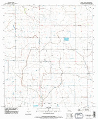 1994 Welsh North1996 Print · USGSJefferson Davis Parish in the mid-1990s shows a landscape defined by its water and energy networks. Genealogists and researchers can trace the area around Pine Island or locate the rural Cem and the winding course of East Bayou Lacassine.
End of results
Showing maps 1-1 of 1
Top cities near Welsh
- Jennings historical maps
- Lake Arthur historical maps
- Iowa historical maps
- Hayes historical maps
- Mermentau historical maps
- Roanoke historical maps
See more
Frequently asked questions
- What are the different types of historical maps available for Welsh?
- What is the oldest map of Welsh?
- Where can I purchase historical maps of Welsh for my home or office?
- Where can I download high-res historical maps of Welsh?
- Are there historical topographic maps available for Welsh?
- Is there historical aerial imagery available for Welsh?
- Where are historical maps of Welsh sourced from?