1930s Maps of Raceland, Louisiana
Explore 5 historic maps of Raceland from the 1930s. These maps offer a rare glimpse into what life looked like during the 1930s — showing old roads, neighborhoods, homes, and landmarks that have changed or disappeared over time.
Whether you're researching your family's past, planning a metal detecting trip, or studying how Raceland's landscape evolved across the 1930s, these high-resolution maps are a powerful tool for exploring the history of this region.
- Focus on a specific era: All maps on this page are from the 1930s, giving you a focused view of this time period.
- See what’s changed: Compare century-old streets, trails, and buildings to today's modern landscape using overlays and satellite layers.
- Research with precision: Use these maps for genealogy, historical research, land use analysis, or educational projects.
- View, download, or print: Maps are fully viewable online in high resolution, and can be downloaded or printed for your own records.
Start exploring Raceland's history through authentic maps from the 1930s. This is your window into the past.
Raceland, LA maps
(5)- 1932 Map of Lac Des Allemands SE
 1932 Lac Des Allemands SE1932 Print · USGSLafourche Parish and the surrounding marshlands are captured in the early 1930s as modern transit began following old rail lines. Researchers can trace the legacy of the sugar and transport economy through landmarks like Roux, the Godchaux Canal, and St Lawrence Ch.
 - 1932 Map of Lac Des Allemands SW
 1932 Lac Des Allemands SW1932 Print · USGSLafourche Parish is captured in the early thirties as a productive landscape of sugar plantations and bayou settlements. Researchers can locate family landmarks like Webster Plantation, trace the route of the Southern Pacific railroad, or find local institutions such as Bush Grove Ch.
 - 1932 Map of Houma NE
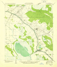 1932 Houma NE1932 Print · USGSLafourche Parish in the early thirties reveals a landscape defined by the serpentine path of Bayou Lafourche and its thriving waterway communities. You can trace early 20th-century life at Lockport and Raceland, or find vanished school sites like Prairie Sch.2 unique versions available
 - 1932 Map of Houma NW
 1932 Houma NW1932 Print · USGSLafourche and Terrebonne Parishes appear here in the early 1930s, showing a landscape shaped by linear bayou settlements and drainage canals. Researchers can trace rural community life through sites like St Louis Chapel, Theriot Siding, and Porche Sch.
 - 1939 Map of Houma, 1956 Print
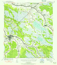 1939 Houma1956 Print · USGSCoastal Louisiana settlement follows the high ridges of the bayous just before the mid-century industrial boom. Genealogists can trace family names and rural landmarks from Aragon Plantation to the St Elie Cem and old Mechanicville neighborhoods.
End of results
Showing maps 1-5 of 5
Top cities near Raceland
Top neighborhoods of Raceland
Frequently asked questions
- What are the different types of historical maps available for Raceland?
- What is the oldest map of Raceland?
- Where can I purchase historical maps of Raceland for my home or office?
- Where can I download high-res historical maps of Raceland?
- Are there historical topographic maps available for Raceland?
- Is there historical aerial imagery available for Raceland?
- Where are historical maps of Raceland sourced from?