1900s (20th Century) Maps of Killian, Louisiana
Explore 12 historic maps of Killian from the 1900s (20th Century). These maps offer a rare glimpse into what life looked like during the 1900s — showing old roads, neighborhoods, homes, and landmarks that have changed or disappeared over time.
Whether you're researching your family's past, planning a metal detecting trip, or studying how Killian's landscape evolved across the 1900s, these high-resolution maps are a powerful tool for exploring the history of this region.
- Focus on a specific era: All maps on this page are from the 1900s, giving you a focused view of this time period.
- See what’s changed: Compare century-old streets, trails, and buildings to today's modern landscape using overlays and satellite layers.
- Research with precision: Use these maps for genealogy, historical research, land use analysis, or educational projects.
- View, download, or print: Maps are fully viewable online in high resolution, and can be downloaded or printed for your own records.
Start exploring Killian's history through authentic maps from the 1900s. This is your window into the past.
Killian, LA maps
(12)- 1934 Map of Springfield
 1934 Springfield1934 Print · USGSLivingston Parish in the early 1930s is a landscape of complex waterways and small riverfront settlements. Genealogists can trace family roots through sites like Davidson Cem, the Hungarian Sch, and many historic landings including Magnolia Ldg.2 unique versions available
 - 1939 Map of Springfield
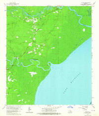
 1939 Springfield1939 Print · USGSCoastal Louisiana at the end of the Depression era reveals a world of river landings and remote parish settlements. Genealogists and researchers can locate family sites like Davidson Cem, local schools such as Hungarian Sch, and numerous river points including Warsaw Log.2 unique versions available
 - 1954 Map of Baton Rouge, 1974 Print
 1954 Baton Rouge1974 Print · USGSSoutheast Louisiana in the mid-fifties is captured here during a period of transition for its river and rail economies. Researchers can trace the path of the Mississippi River and find landmarks like the Bonnet Carre Spillway and Bayou Plaquemine.2 unique versions available
 - 1956 Map of Baton Rouge
 1956 Baton Rouge1956 Print · USGSSouth Louisiana at the height of the mid-century oil boom shows a landscape of river oxbows and rising industry. Researchers can trace family roots through river towns like Scotlandville or locate early industrial sites and Oil wells near Lake Maurepas.
 - 1961 Map of Baton Rouge, 1966 Print
 1961 Baton Rouge1966 Print · USGSSoutheastern Louisiana in the early sixties remains a landscape of deep river bends and sprawling coastal lakes. Genealogists and historians can trace the rail-and-river economy through landmarks like Free-Nigger Point, Donaldsonville, and the Illinois Central Railroad.
 - 1962 Map of Baton Rouge
 1962 Baton Rouge1962 Print · USGSSouth Louisiana in the early sixties reveals a landscape of river-bend parishes and emerging interstate corridors. Genealogists and historians can trace family roots through historic river towns like Donaldsonville and Plaquemine, or follow the path of the Illinois Central Railroad through the swamp basins.
 - 1963 Map of Killian, 1964 Print
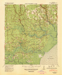
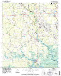
 1963 Killian1964 Print · USGSLivingston Parish at the edge of the wetlands in the early sixties reveals a community closely tied to its rivers and bayous. Researchers can trace family sites like McKinney Cem and Davidson Cem or locate old landings such as Carthage Bluff Landing.4 unique versions available
 - 1963 Map of Springfield, 1964 Print
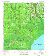
 1963 Springfield1964 Print · USGSLouisiana's river country comes to life in this early 1960s survey of the parish borderlands near the Natalbany River. Local historians can locate numerous rural landmarks like Warsaw Landing, Hungarian Ch, and the Albany-Springfield High Sch.4 unique versions available
 - 1963 Map of Springfield, 1967 Print
 1963 Springfield1967 Print · USGSThe Louisiana bayou country north of Lake Maurepas comes alive in the mid-1960s, showing a landscape of river landings and parish crossroads. Genealogists can trace family roots through sites like Redding Cem, Jefferson Cem, and the rural James Chapel.2 unique versions available
 - 1965 Map of Springfield
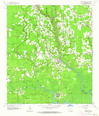
 1965 Springfield1965 Print · USGSLivingston Parish in the mid-1960s reveals a complex network of river landings and lowland settlements as they existed before modern expansion. Genealogists and historians can locate the Hungarian Settlement, numerous country churches like Holly Ch, and family cemeteries including McLin Cem and Carters Cem.
 - 1983 Map of Ponchatoula, 1984 Print
 1983 Ponchatoula1984 Print · USGSThe Lake Pontchartrain Basin and the River Parishes come into focus during the early 1980s, showcasing the region's complex water-dependent geography. Researchers can trace the rail routes of the Illinois Central Gulf Railroad and explore landmarks from Pass Manchac to Donaldsonville.2 unique versions available
 - 1994 Map of Springfield, 1996 Print
 1994 Springfield1996 Print · USGSLivingston and Tangipahoa Parishes are shown in the mid-1990s as modern highway infrastructure met the ancient wetlands of the Tickfaw basin. Genealogists can locate family sites at Galilee Cem or Carters Cem and trace the old river settlements at Springfield and Warsaw Landing.
End of results
Showing maps 1-12 of 12
Top cities near Killian
- Hammond historical maps
- Walker historical maps
- Ponchatoula historical maps
- Maurepas historical maps
- Livingston historical maps
- Albany historical maps
See more
Frequently asked questions
- What are the different types of historical maps available for Killian?
- What is the oldest map of Killian?
- Where can I purchase historical maps of Killian for my home or office?
- Where can I download high-res historical maps of Killian?
- Are there historical topographic maps available for Killian?
- Is there historical aerial imagery available for Killian?
- Where are historical maps of Killian sourced from?