1900s (20th Century) Maps of Log Cabin, Louisiana
Explore 8 historic maps of Log Cabin from the 1900s (20th Century). These maps offer a rare glimpse into what life looked like during the 1900s — showing old roads, neighborhoods, homes, and landmarks that have changed or disappeared over time.
Whether you're researching your family's past, planning a metal detecting trip, or studying how Log Cabin's landscape evolved across the 1900s, these high-resolution maps are a powerful tool for exploring the history of this region.
- Focus on a specific era: All maps on this page are from the 1900s, giving you a focused view of this time period.
- See what’s changed: Compare century-old streets, trails, and buildings to today's modern landscape using overlays and satellite layers.
- Research with precision: Use these maps for genealogy, historical research, land use analysis, or educational projects.
- View, download, or print: Maps are fully viewable online in high resolution, and can be downloaded or printed for your own records.
Start exploring Log Cabin's history through authentic maps from the 1900s. This is your window into the past.
Log Cabin, LA maps
(8)- 1935 Map of Naff, 1936 Print
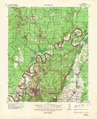 1935 Naff1936 Print · USGSMorehouse Parish in the mid-1930s is a landscape of winding bayous and emerging industrial infrastructure. Genealogists and local historians can trace family locations near Bastrop, Shelton, and rural landmarks like Evergreen Ch and Cem or Pt Pleasant.
 - 1955 Map of Jackson
 1955 Jackson1955 Print · USGSThe Lower Mississippi Valley at the middle of the century reveals a landscape of deep river meanders and growing rail hubs. Genealogists and historians can trace the mid-century footprints of Vicksburg National Military Park, old river landings at Port Gibson, and the rail corridors of the Illinois Central Railroad.3 unique versions available
 - 1956 Map of Bastrop, 1957 Print
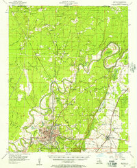 1956 Bastrop1957 Print · USGSMorehouse Parish in the mid-1950s is a landscape of thriving rail hubs and productive wetlands at the edge of the Arkansas border. Genealogists and historians can trace family roots through landmarks like Cherry Ridge Sch, Mer Rouge, and the Gas and Oil Field near Beekman.4 unique versions available
 - 1961 Map of Jackson
 1961 Jackson1961 Print · USGSThe Lower Mississippi Delta and the state capital area are captured here during the post-war era of infrastructure expansion. Researchers can trace the complex river oxbows and rail lines connecting Vicksburg, Yazoo City, and the Illinois Central Railroad network.
 - 1962 Map of Jackson
 1962 Jackson1962 Print · USGSThe Mississippi Delta and the state capital region are mapped here in the early sixties, showing a landscape defined by the great river and the growing city of JACKSON. Genealogists can trace family roots through numerous landmarks like Cedar Hill Cem, rural stops on the Illinois Central RR, and historic sites like Champion Hill.2 unique versions available
 - 1982 Map of Bastrop, 1983 Print
 1982 Bastrop1983 Print · USGSNortheastern Louisiana and the Mississippi River Delta are captured here in the early eighties as a landscape of bayous and river towns. Genealogists and historians can trace small communities like Mer Rouge and Oak Grove or the ancient terrain of Poverty Point State Park.
 - 1988 Map of Bastrop
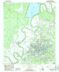 1988 Bastrop1988 Print · USGSBastrop and its surrounding wetlands are captured here in the late eighties, showing the town at a peak of municipal development. Researchers can trace the layout of outlying settlements like Newblock and Sheltons or locate family landmarks near Bussy Brake and Anderson Lake.
 - 1994 Map of Bastrop, 1995 Print
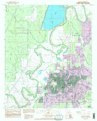 1994 Bastrop1995 Print · USGSBastrop and its surrounding wetlands are captured here in the mid-1990s, showcasing the area's growth and timber-driven land use. Trace old neighborhood lines in Newblock, local aviation at Morehouse Memorial Airport, or the levees of Bussy Brake.
End of results
Showing maps 1-8 of 8
Top cities near Log Cabin
- Monroe historical maps
- Bastrop historical maps
- Sterlington historical maps
- Mer Rouge historical maps
- Bonita historical maps
- Collinston historical maps
See more
Frequently asked questions
- What are the different types of historical maps available for Log Cabin?
- What is the oldest map of Log Cabin?
- Where can I purchase historical maps of Log Cabin for my home or office?
- Where can I download high-res historical maps of Log Cabin?
- Are there historical topographic maps available for Log Cabin?
- Is there historical aerial imagery available for Log Cabin?
- Where are historical maps of Log Cabin sourced from?