1930s Maps of Upland, Louisiana
Explore 1 historic maps of Upland from the 1930s. These maps offer a rare glimpse into what life looked like during the 1930s — showing old roads, neighborhoods, homes, and landmarks that have changed or disappeared over time.
Whether you're researching your family's past, planning a metal detecting trip, or studying how Upland's landscape evolved across the 1930s, these high-resolution maps are a powerful tool for exploring the history of this region.
- Focus on a specific era: All maps on this page are from the 1930s, giving you a focused view of this time period.
- See what’s changed: Compare century-old streets, trails, and buildings to today's modern landscape using overlays and satellite layers.
- Research with precision: Use these maps for genealogy, historical research, land use analysis, or educational projects.
- View, download, or print: Maps are fully viewable online in high resolution, and can be downloaded or printed for your own records.
Start exploring Upland's history through authentic maps from the 1930s. This is your window into the past.
Upland, LA maps
(1)- 1935 Map of Collinston
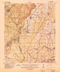 1935 Collinston1935 Print · USGSMorehouse and Ouachita Parishes are seen here in the mid-1930s during a period of heavy industrialization fueled by the natural gas boom. Researchers can trace the sprawling footprints of the Southern Carbon Co and find rural landmarks like Jerusalem Ch and the Indian Mounds.
End of results
Showing maps 1-1 of 1
Top cities near Upland
- Monroe historical maps
- Bastrop historical maps
- Swartz historical maps
- Sterlington historical maps
- Mer Rouge historical maps
- Bonita historical maps
See more
Frequently asked questions
- What are the different types of historical maps available for Upland?
- What is the oldest map of Upland?
- Where can I purchase historical maps of Upland for my home or office?
- Where can I download high-res historical maps of Upland?
- Are there historical topographic maps available for Upland?
- Is there historical aerial imagery available for Upland?
- Where are historical maps of Upland sourced from?