1940s Maps of Natchitoches Parish, Louisiana
Explore 20 historic maps of Natchitoches Parish from the 1940s. These maps offer a rare glimpse into what life looked like during the 1940s — showing old roads, neighborhoods, homes, and landmarks that have changed or disappeared over time.
Whether you're researching your family's past, planning a metal detecting trip, or studying how Natchitoches Parish's landscape evolved across the 1940s, these high-resolution maps are a powerful tool for exploring the history of this region.
- Focus on a specific era: All maps on this page are from the 1940s, giving you a focused view of this time period.
- See what’s changed: Compare century-old streets, trails, and buildings to today's modern landscape using overlays and satellite layers.
- Research with precision: Use these maps for genealogy, historical research, land use analysis, or educational projects.
- View, download, or print: Maps are fully viewable online in high resolution, and can be downloaded or printed for your own records.
Start exploring Natchitoches Parish's history through authentic maps from the 1940s. This is your window into the past.
Natchitoches Parish, LA maps
(20)- 1941 Map of Boyce, 1945 Print
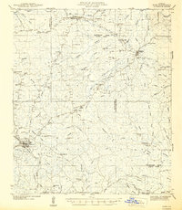
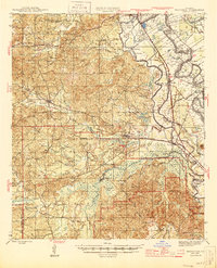
 1941 Boyce1945 Print · USGSRapides Parish was a landscape of river plantations and pine forests in the early 1940s. Genealogists and historians can locate numerous rural landmarks like Hotwells, Fairmount Plantation, and the Israelite Ch Sch & Cem along the Red River.2 unique versions available
 - 1942 Map of Many
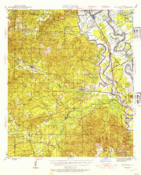
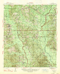
 1942 Many1942 Print · USGSSabine and Natchitoches Parishes are shown here in the early 1940s, a landscape defined by timber, railroads, and tight-knit rural communities. You can trace early family sites at Fort Jesup, find remote country schools like Armstrong Sch, and locate the CCC Camp.2 unique versions available
 - 1942 Map of Kisatchie
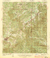
 1942 Kisatchie1942 Print · USGSThe timberlands of Natchitoches and Vernon Parishes are captured here in the early 1940s, showing the dense network of company towns and rail lines. Genealogists and researchers can locate timber settlements like Alco, Kurthwood, and Hutton, plus the CCC Camp and Silver Creek Church.
 - 1942 Map of Montgomery, 1956 Print
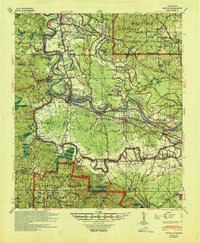
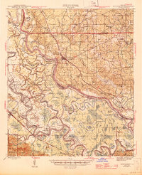
 1942 Montgomery1956 Print · USGSCentral Louisiana parish borders meet along the shifting bends of the Red River during the early 1940s. Genealogists and historians can trace the dense settlement of the Cane River valley through landmarks like Cloutierville, St Augustines Ch, and Melrose.
 - 1943 Map of Many
 1943 Many1943 Print · USGSSabine Parish during the early years of the war shows a landscape of timber camps and rail-dependent villages. Genealogists can trace family names through dozens of landmarks like Mt Carmel Cem, Fort Jesup, and the CCC Camp.
 - 1943 Map of Kisatchie
 1943 Kisatchie1943 Print · USGSDuring the early 1940s, this portion of Natchitoches Parish was a hive of timber activity centered around the Red River and Gulf Railroad. Researchers can trace old industry sites like Kurthwood and Alco or locate family sites at Robinson Cem and Kisatchie Union Ch.
 - 1943 Map of Provencal, 1954 Print
 1943 Provencal1954 Print · USGSNatchitoches Parish during the early 1940s reveals a landscape defined by the winding Red River and the Texas and Pacific RR. Genealogists can trace rural roots through landmarks like Friendship Cem, St Marks Ch, and the community at Bermuda.
 - 1944 Map of Chopin
 1944 Chopin1944 Print · USGSCentral Louisiana during the early 1940s shows a landscape defined by timber harvesting and the winding Red River. Local historians can trace logging tracks and old community centers like Zimmerman Camp, Mora Ch, and Galbraith Sta.
 - 1944 Map of Campti, 1955 Print
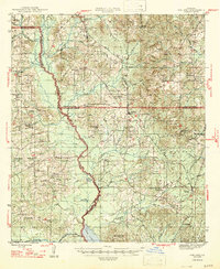
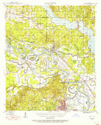 1944 Campti1955 Print · USGSNatchitoches and the Red River valley are shown here during the mid-1940s, highlighting a landscape of river bends and rail-dependent settlements. Researchers can trace family roots through numerous country landmarks like Bethlehem Sch, St Lukes Cem, and the river port at Grand Ecore.
 - 1945 Map of Montgomery
 1945 Montgomery1945 Print · USGSCentral Louisiana life during the 1940s centered on the Red River and the expanding timber industry. Researchers can trace historic family landmarks through schools like Cockfield Sch, churches such as Mt Zion Ch, and the numerous bayous of the Kisatchie National Forest.
 - 1945 Map of Provencal
 1945 Provencal1945 Print · USGSNatchitoches Parish during the mid-1940s is defined by its complex network of waterways and the Texas and Pacific RR. Researchers can locate rural landmarks like Rockford Sch, Beasley Crossing, and the Bayou Gorum Post Office.
 - 1947 Map of Goldonna
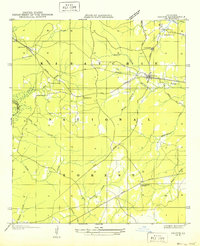
 1947 Goldonna1947 Print · USGSNorth Louisiana's timber and rail country is captured here just after the war, showing the rural communities of Natchitoches and Bienville Parishes. Researchers can locate local landmarks like Blooms Mill, trace the Louisiana and Arkansas Railroad, or find old school sites like Readhimer Sch.
 - 1947 Map of Ashland
 1947 Ashland1947 Print · USGSNorth Louisiana's parish boundaries converge in this mid-century landscape where timber and rail lines defined daily life. Genealogists can locate numerous rural landmarks like St Mathews Ch, Old Saline Cem, and the old rail stop at Ashland.
 - 1947 Map of Hanna
 1947 Hanna1947 Print · USGSRed River Parish and Natchitoches Parish are shown in the late 1940s, a period when the river valley remained a landscape of ferries, rural schools, and bayous. Genealogists can trace family landmarks like the Rambin Store, Jordon Ferry, and St James Cem.
 - 1948 Map of Campti
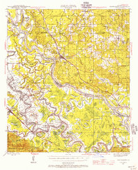
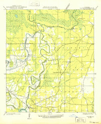
 1948 Campti1948 Print · USGSNatchitoches Parish and the Red River valley are captured in the late 1940s, showing a landscape defined by oxbows and rural life. Researchers can trace historic schools and churches from Campti to Powhatan, including Bethel Cem and Grappes Bluff.2 unique versions available
 - 1948 Map of Chopin, 1956 Print
 1948 Chopin1956 Print · USGSLouisiana's timber and rail history comes to life in this mid-century survey of the rural backcountry spanning Natchitoches and Rapides Parishes. Researchers can trace the legacy of small communities and family-named sites like Galbraith Sta, Temple Spur, and the Blackwell Cem.
 - 1949 Map of Boyce NW
 1949 Boyce NW1949 Print · USGSThe Red River valley in the late 1940s reveals a landscape of oxbow lakes and essential rail junctions near the parish borders. Genealogists can locate family landmarks such as Zion Harp Ch, St Matthis Sch, and the small community of Zimmerman.
 - 1949 Map of Calvin NE
 1949 Calvin NE1949 Print · USGSWinn Parish at the end of the 1940s reveals a landscape of dense national forest and dispersed rural life. Researchers can locate family landmarks such as Sanders Ch, the CCC Camp, and the Gum Springs Lookout along the winding parish creeks.
 - 1949 Map of Calvin NW
 1949 Calvin NW1949 Print · USGSThe rural marshlands of Natchitoches Parish are documented here in the late 1940s, showing the eastern edge of the Kisatchie National Forest. Genealogists and historians can trace local landmarks like Evergreen Ch, Clear Lake Sch, and the winding Saline Bayou.
 - 1949 Map of Calvin SW
 1949 Calvin SW1949 Print · USGSThe parish line of Natchitoches and Winn follows the twisting course of Saline Bayou during the late Forties. Researchers can trace the rural layout of churches and schools like Christian Harmony Ch, Pace Sch, and St Maurice along the river.
End of results
Showing maps 1-20 of 20
Top cities of Natchitoches Parish
- Natchitoches historical maps
- Campti historical maps
- Natchez historical maps
- Provencal historical maps
- Clarence historical maps
- Goldonna historical maps
See more
Frequently asked questions
- What are the different types of historical maps available for Natchitoches Parish?
- What is the oldest map of Natchitoches Parish?
- Where can I purchase historical maps of Natchitoches Parish for my home or office?
- Where can I download high-res historical maps of Natchitoches Parish?
- Are there historical topographic maps available for Natchitoches Parish?
- Is there historical aerial imagery available for Natchitoches Parish?
- Where are historical maps of Natchitoches Parish sourced from?