1990s Maps of Orleans Parish, Louisiana
Explore 14 historic maps of Orleans Parish from the 1990s. These maps offer a rare glimpse into what life looked like during the 1990s — showing old roads, neighborhoods, homes, and landmarks that have changed or disappeared over time.
Whether you're researching your family's past, planning a metal detecting trip, or studying how Orleans Parish's landscape evolved across the 1990s, these high-resolution maps are a powerful tool for exploring the history of this region.
- Focus on a specific era: All maps on this page are from the 1990s, giving you a focused view of this time period.
- See what’s changed: Compare century-old streets, trails, and buildings to today's modern landscape using overlays and satellite layers.
- Research with precision: Use these maps for genealogy, historical research, land use analysis, or educational projects.
- View, download, or print: Maps are fully viewable online in high resolution, and can be downloaded or printed for your own records.
Start exploring Orleans Parish's history through authentic maps from the 1990s. This is your window into the past.
Orleans Parish, LA maps
(14)- 1992 Map of Spanish Fort
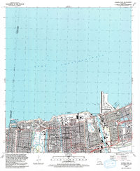 1992 Spanish Fort1992 Print · USGSThe northern lakefront of New Orleans is shown here in the early nineties, featuring a highly developed shoreline of harbors and universities. Researchers can trace local landmarks like Spanish Fort, City Park, and the Hebrew Rest Cem.2 unique versions available
 - 1992 Map of New Orleans West
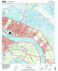
 1992 New Orleans West1992 Print · USGSGreater New Orleans is shown in high detail during the early nineties, centered on the river's sharp turns and industrial hubs. Genealogists and local historians can trace family roots through numerous parish schools and landmarks like Providence Memorial Park and the Huey P Long Bridge.2 unique versions available
 - 1992 Map of New Orleans East
 1992 New Orleans East1992 Print · USGSGreater New Orleans at the start of the nineties reveals a complex urban landscape shaped by the Mississippi River and industrial waterways. Trace neighborhood history through family-named landmarks like McDonoghville and historic sites like Metairie Cemetery or the Vieux Carre.
 - 1993 Map of Rigolets, 1995 Print
 1993 Rigolets1995 Print · USGSThe Louisiana coast near the Pearl River mouth comes to life in the early 1990s, where the deep-water passes of The Rigolets meet the marsh. Historians can trace the grounds of Fort Pike, locate the McKean Cem, and explore the maze of the Pearl River State Wildlife Management Area.
 - 1994 Map of Alligator Point, 1995 Print
 1994 Alligator Point1995 Print · USGSCoastal Orleans Parish in the mid-1990s reveals a complex network of marshland, waterways, and industrial extraction. Map collectors and researchers can trace the reach of the Lake Borgne Gas Field and landmarks like Alligator Point and Shell Point.
 - 1998 Map of Chef Menteur, 1999 Print
 1998 Chef Menteur1999 Print · USGSThe Louisiana coast near the turn of the millennium shows the intersection of historic defense and modern canal-front living. Trace the ruins of Fort Macomb at Chef Menteur Pass or explore the residential waterways of Venetian Isles.
 - 1998 Map of New Orleans West, 2000 Print
 1998 New Orleans West2000 Print · USGSJefferson Parish and the West Bank are shown in detail at the end of the millennium, as suburban growth met the industrial riverfront. Trace the intricate rail lines of the Illinois Central Gulf RR or locate family sites near Garden of Memories (Cem) and Lafreniere Park.
 - 1998 Map of New Orleans East, 2000 Print
 1998 New Orleans East2000 Print · USGSNew Orleans and the West Bank are shown at the end of the century, detailing the dense urban fabric and the great bend of the river. Genealogists can trace hundreds of sites including St Louis Cathedral, Metairie Cemetery, and the extensive McDonogh No 26 Sch system.
 - 1998 Map of Chalmette, 2001 Print
 1998 Chalmette2001 Print · USGSCoastal Louisiana at the close of the twentieth century shows a landscape defined by the great river and the expanding footprint of St. Bernard Parish. Genealogists and historians can trace neighborhood growth in Chalmette Vista and Meraux, or locate family sites near St Bernard Memorial Gardens (Cem) and Jackson Barracks.
 - 1998 Map of Martello Castle, 2001 Print
 1998 Martello Castle2001 Print · USGSSt. Bernard Parish at the close of the twentieth century reveals a landscape shaped by massive maritime engineering. Researchers can trace the path of the Mississippi River - Gulf Outlet Canal past Martello Castle and through a maze of coastal waters like Pirogue Bayou.
 - 1998 Map of Little Woods, 2001 Print
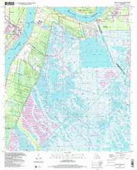
 1998 Little Woods2001 Print · USGSEastern New Orleans at the close of the twentieth century shows a fascinating intersection of urban expansion and coastal marshland. Researchers can trace neighborhood landmarks like Resthaven Memorial Park and the massive NASA facility.
 - 1998 Map of Rigolets, 2002 Print
 1998 Rigolets2002 Print · USGSCoastal St. Tammany Parish at the close of the century is a complex network of bayous, islands, and historical defenses. You can trace the footprint of Fort Pike State Historic Site, locate White Kitchen, and explore the marshes of Weems Island.
 - 1999 Map of Spanish Fort, 2000 Print
 1999 Spanish Fort2000 Print · USGSThe Lake Pontchartrain shoreline in northern New Orleans appears here just before the turn of the millennium. Researchers can trace the layout of historic Spanish Fort, locate the cluster of Jewish Cemeteries, and see the development around Seabrook.
 - 1999 Map of Belle Chasse, 2000 Print
 1999 Belle Chasse2000 Print · USGSThe Mississippi River corridor south of New Orleans reveals a mix of military aviation and deep-delta marshland during the late twentieth century. Genealogists and historians can trace family-named sites like Bethlehem Ch, follow the Old Railroad Grade, or locate the Sea Train Terminal.
End of results
Showing maps 1-14 of 14
Top cities of Orleans Parish
Frequently asked questions
- What are the different types of historical maps available for Orleans Parish?
- What is the oldest map of Orleans Parish?
- Where can I purchase historical maps of Orleans Parish for my home or office?
- Where can I download high-res historical maps of Orleans Parish?
- Are there historical topographic maps available for Orleans Parish?
- Is there historical aerial imagery available for Orleans Parish?
- Where are historical maps of Orleans Parish sourced from?