1940s Maps of Orleans Parish, Louisiana
Explore 7 historic maps of Orleans Parish from the 1940s. These maps offer a rare glimpse into what life looked like during the 1940s — showing old roads, neighborhoods, homes, and landmarks that have changed or disappeared over time.
Whether you're researching your family's past, planning a metal detecting trip, or studying how Orleans Parish's landscape evolved across the 1940s, these high-resolution maps are a powerful tool for exploring the history of this region.
- Focus on a specific era: All maps on this page are from the 1940s, giving you a focused view of this time period.
- See what’s changed: Compare century-old streets, trails, and buildings to today's modern landscape using overlays and satellite layers.
- Research with precision: Use these maps for genealogy, historical research, land use analysis, or educational projects.
- View, download, or print: Maps are fully viewable online in high resolution, and can be downloaded or printed for your own records.
Start exploring Orleans Parish's history through authentic maps from the 1940s. This is your window into the past.
Orleans Parish, LA maps
(7)- 1940 Map of Belle Chasse
 1940 Belle Chasse1940 Print · USGSCoastal Louisiana during the late 1930s is defined here by its intricate canal systems and riverside rail hubs. Trace the local economy through the Sea Train Terminal at Belle Chasse or the marshland paths near Tigers Ridge and Lake Lery.
 - 1942 Map of St. Bernard, 1949 Print
 1942 St. Bernard1949 Print · USGSCoastal St. Bernard and Plaquemines Parishes are shown during the early 1940s, capturing the delta’s transition from rural settlements to an industrial oil and rail corridor. Researchers can trace family roots at the Delacroix Island School or locate historic sites like Chalmette National Monument and the Martello Tower.
 - 1943 Map of Little Woods
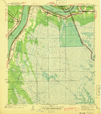
 1943 Little Woods1943 Print · USGSThe eastern reaches of New Orleans in the early 1940s reveal a landscape in transition as drainage canals began to reshape the historic marshlands. Genealogists and historians can trace early lakeside settlements like Little Woods and Micheaud, as well as the paths of the Southern Railway and the winding Bayou Sauvage.
 - 1945 Map of New Orleans
 1945 New Orleans1945 Print · USGSCoastal Louisiana and the Mississippi delta are captured here just after the war, showing the region's transition into a modern industrial and transit hub. Genealogists can trace family settlements along Bayou Teche or identify rail stops for the Illinois Central and Texas & Pacific lines.
 - 1946 Map of Rigolets
 1946 Rigolets1946 Print · USGSCoastal St. Tammany Parish at the end of the Second World War was a labyrinth of tidal passes and marsh ridges. Genealogists and historians can trace the strategic layout of Ft Pike, the small settlement at Rigolets, and the remote W Rigolets L H light station.
 - 1947 Map of Martello Castle
 1947 Martello Castle1947 Print · USGSThe St. Bernard Parish wetlands appear in high detail during the 1940s, just as the coast began to see major industrial changes. Researchers can trace the original paths of Bayou Dupre and Shell Beach Bayou or locate the historic Martello Castle.
 - 1949 Map of Alligator Point
 1949 Alligator Point1949 Print · USGSThe marshlands of Orleans Parish are seen here in the late 1940s, dominated by coastal bayous and the lone corridor of the Louisville and Nashville rail line. Researchers can trace the winding paths of Bayou Truloix and Bayou Sapath as they meet the shores of Lake Borgne.
End of results
Showing maps 1-7 of 7
Top cities of Orleans Parish
Frequently asked questions
- What are the different types of historical maps available for Orleans Parish?
- What is the oldest map of Orleans Parish?
- Where can I purchase historical maps of Orleans Parish for my home or office?
- Where can I download high-res historical maps of Orleans Parish?
- Are there historical topographic maps available for Orleans Parish?
- Is there historical aerial imagery available for Orleans Parish?
- Where are historical maps of Orleans Parish sourced from?