1900s (20th Century) Maps of Venice, Louisiana
Explore 10 historic maps of Venice from the 1900s (20th Century). These maps offer a rare glimpse into what life looked like during the 1900s — showing old roads, neighborhoods, homes, and landmarks that have changed or disappeared over time.
Whether you're researching your family's past, planning a metal detecting trip, or studying how Venice's landscape evolved across the 1900s, these high-resolution maps are a powerful tool for exploring the history of this region.
- Focus on a specific era: All maps on this page are from the 1900s, giving you a focused view of this time period.
- See what’s changed: Compare century-old streets, trails, and buildings to today's modern landscape using overlays and satellite layers.
- Research with precision: Use these maps for genealogy, historical research, land use analysis, or educational projects.
- View, download, or print: Maps are fully viewable online in high resolution, and can be downloaded or printed for your own records.
Start exploring Venice's history through authentic maps from the 1900s. This is your window into the past.
Venice, LA maps
(10)- 1947 Map of Venice
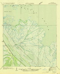 1947 Venice1947 Print · USGSThe Mississippi Delta's southern reaches are captured here in the mid-1940s, centered on the vital river outpost of Venice. Local historians can trace the complex network of delta passes and bays, from the strategic waters of The Jump to Spanish Pass and Grand Pass.
 - 1948 Map of Forts, 1960 Print
 1948 Forts1960 Print · USGSLower Plaquemines Parish in the late 1940s reveals a world of river settlements and coastal fortifications before the landscape was reshaped by modern industry. Researchers can trace family sites near Triumph or explore the historic grounds of Fort Jackson and Fort St Philip.
 - 1954 Map of Venice
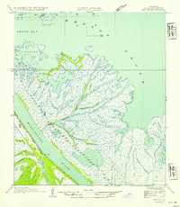 1954 Venice1954 Print · USGSThe Plaquemines Parish coastline in the mid-fifties reveals a labyrinth of deltaic waterways where the river meets the sea. Genealogists and historians can trace the early layout of Venice and the vital distributaries at The Jump, Tiger Pass, and Collette Baptiste.
 - 1957 Map of Breton Sound, 1967 Print
 1957 Breton Sound1967 Print · USGSThe Mississippi River delta is captured here in the mid-fifties, showing the fragile marshlands and river-dependent towns of the Louisiana coast. Genealogists and historians can trace riverside settlements like Pointe a la Hache, Pilottown, and Port Sulphur.3 unique versions available
 - 1960 Map of Forts, 1961 Print
 1960 Forts1961 Print · USGSThe lower Mississippi River delta in the early sixties was a landscape defined by the intersection of river settlements and the emerging oil industry. Researchers can trace the riverfront communities of Boothville and Venice, or locate historic sites like Fort St Philip and the Boothville Cem.3 unique versions available
 - 1961 Map of Breton Sound
 1961 Breton Sound1961 Print · USGSThe Louisiana delta and the outer marshes of Plaquemines Parish are captured here at the start of the 1960s. Researchers can trace the river settlements from Davant to Venice, locate isolated stations like Port Eads, and find old sites such as Fort Jackson.
 - 1971 Map of Venice, 1974 Print
 1971 Venice1974 Print · USGSThe Mississippi Delta's tip reveals a landscape of industrial ambition and coastal marsh in the early 1970s. Trace the working waterfront of Venice and locate family landmarks like Full Gospel Ch or the Boothville Cem alongside the dredging and rigs of Breton Sound.2 unique versions available
 - 1983 Map of Mississippi River Delta
 1983 Mississippi River Delta1983 Print · USGSThe lower Mississippi delta in the early eighties shows the thin line of human habitation clinging to the river levee between the vast marshes and the gulf. Genealogists and historians can trace the riverside communities of Empire, Triumph, and Nairn alongside the industrial Sulphur Mining Area.2 unique versions available
 - 1993 Map of Venice
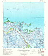
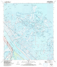 1993 Venice1993 Print · USGSThe Plaquemines Parish marshlands are captured here in the early nineties, showing where the Mississippi River splits into the Gulf of Mexico. Researchers can trace the industrial footprint of the Oil and Gas Field and find local landmarks like The Jump and Full Gospel Ch.
 - 1998 Map of Venice, 2001 Print
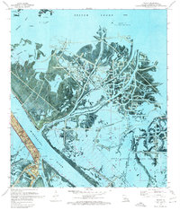
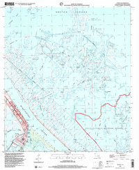 1998 Venice2001 Print · USGSThe Mississippi Delta's edge comes into focus in the late nineties, where the river meets a maze of marsh and industry. Researchers can trace the levee-protected communities of Venice and Boothville, finding local landmarks like the Full Gospel Ch and The Jump.
End of results
Showing maps 1-10 of 10
Top cities near Venice
Frequently asked questions
- What are the different types of historical maps available for Venice?
- What is the oldest map of Venice?
- Where can I purchase historical maps of Venice for my home or office?
- Where can I download high-res historical maps of Venice?
- Are there historical topographic maps available for Venice?
- Is there historical aerial imagery available for Venice?
- Where are historical maps of Venice sourced from?