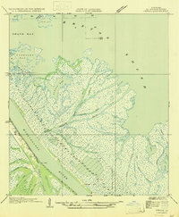
1947 Map of Venice
USGS Topo · Published 1947About this map
Venice serves as the terminal hub for navigation on the lower Mississippi River, positioned where the river begins its final branching into the delta. The landscape is defined by an intricate network of distributaries and bays, including the sprawling Alexis Bay and Breton Sound. Of particular importance is The Jump, a significant crevasse and waterway junction that diverts river flow into the surrounding wetlands. This 1947 edition, based on earlier Air Corps aerial photography and field examinations, illustrates the complex deltaic hydrology of the era through named passes such as Main Lookout Pass, Kimbel Pass, and Tiger Pass. Extensive marshlands like Wilder Flats and numerous bayous, such as Baptiste Collette Bayou and Porpoise Bayou, highlight the precarious balance between land and water at the edge of the Gulf.
Find a feature on this map
27 named features on this map. Tap any name to fly to it.
Don’t see what you’re looking for? This feature index may not catch every label — zoom into the map to look around manually.
Map Details
Editions of this 1947 Venice Map
This is the sole edition of this map. No revisions or reprints were ever made.
Other maps of this area
1893 · East Delta
USGS Topo · 1:62,500
1893 · Forts
USGS Topo · 1:62,500
1893 · West Delta
USGS Topo · 1:62,500

1935 · Taylor Pass
USGS Topo · 1:31,680

1946 · Pass Tante Phine
USGS Topo · 1:31,680

1947 · Pass A Loutre West
USGS Topo · 1:31,680

1947 · Fort St. Philip
USGS Topo · 1:31,680

1947 · Main Pass
USGS Topo · 1:31,680

1948 · Forts
USGS Topo · 1:62,500

1949 · Cubits Gap
USGS Topo · 1:31,680