
1947 Map of Main Pass
USGS Topo · Published 1947About this map
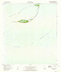
Breton Sound meets the intricate marshlands of the Mississippi River Delta in this 1947 survey, where a complex network of bayous and ponds defines the Plaquemines Parish coastline. The map illustrates a landscape dominated by shifting water and land, characterized by features like Salle De Danse and Octave Pass. A single man-made landmark, the Duck Club, stands near the edge of the wetlands, suggesting the area's primary use for recreation and hunting during the mid-twentieth century. Natural formations such as Timber Island and Harris Island emerge from the delta, while specific water bodies like Piling Pond, Blackbird Pond, and Speckled Goose Pond highlight the local fauna that once thrived in these tidal reaches. The intricate detail of Flatboat Bayou and Delta Pass shows the navigational challenges of the era before modern land loss significantly altered these shores.
Find a feature on this map
77 named features on this map. Tap any name to fly to it.
Don’t see what you’re looking for? This feature index may not catch every label — zoom into the map to look around manually.
Map Details
Editions of this 1947 Main Pass Map
This is the sole edition of this map. No revisions or reprints were ever made.
Other maps of this area

1893 · East Delta
USGS Topo · 1:62,500

1893 · Forts
USGS Topo · 1:62,500

1893 · West Delta
USGS Topo · 1:62,500

1935 · Taylor Pass
USGS Topo · 1:31,680

1947 · Pass A Loutre West
USGS Topo · 1:31,680

1947 · Venice
USGS Topo · 1:31,680

1947 · Pass A Loutre East
USGS Topo · 1:31,680

1948 · Forts
USGS Topo · 1:62,500

1949 · Cubits Gap
USGS Topo · 1:31,680
1950 · Breton Islands
USGS Topo · 1:24,000