1960s Maps of Morganza, Louisiana
Explore 5 historic maps of Morganza from the 1960s. These maps offer a rare glimpse into what life looked like during the 1960s — showing old roads, neighborhoods, homes, and landmarks that have changed or disappeared over time.
Whether you're researching your family's past, planning a metal detecting trip, or studying how Morganza's landscape evolved across the 1960s, these high-resolution maps are a powerful tool for exploring the history of this region.
- Focus on a specific era: All maps on this page are from the 1960s, giving you a focused view of this time period.
- See what’s changed: Compare century-old streets, trails, and buildings to today's modern landscape using overlays and satellite layers.
- Research with precision: Use these maps for genealogy, historical research, land use analysis, or educational projects.
- View, download, or print: Maps are fully viewable online in high resolution, and can be downloaded or printed for your own records.
Start exploring Morganza's history through authentic maps from the 1960s. This is your window into the past.
Morganza, LA maps
(5)- 1961 Map of Baton Rouge, 1966 Print
 1961 Baton Rouge1966 Print · USGSSoutheastern Louisiana in the early sixties remains a landscape of deep river bends and sprawling coastal lakes. Genealogists and historians can trace the rail-and-river economy through landmarks like Free-Nigger Point, Donaldsonville, and the Illinois Central Railroad.
 - 1962 Map of Baton Rouge
 1962 Baton Rouge1962 Print · USGSSouth Louisiana in the early sixties reveals a landscape of river-bend parishes and emerging interstate corridors. Genealogists and historians can trace family roots through historic river towns like Donaldsonville and Plaquemine, or follow the path of the Illinois Central Railroad through the swamp basins.
 - 1965 Map of Lacour, 1966 Print
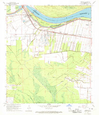
 1965 Lacour1966 Print · USGSMid-century life in Pointe Coupee Parish is shaped by the great river and the massive levees of the Morganza Floodway. Genealogists and historians can trace the foundations of Lacour and find local landmarks like Jerusalem Ch and the Texas and Pacific Railway.4 unique versions available
 - 1967 Map of Batchelor, 1969 Print
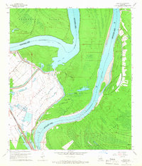
 1967 Batchelor1969 Print · USGSPointe Coupee Parish and West Feliciana Parish meet at this complex Mississippi River junction in the late sixties. Genealogists and historians can trace the foundations of Angola, explore family sites like St Marks Ch Cem, or study the massive Morganza Control Structure.
 - 1968 Map of Morganza, 1970 Print
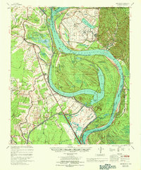
 1968 Morganza1970 Print · USGSLouisiana's river engineering is on full display in the late 1960s as the massive floodway system meets the Mississippi. Genealogists can locate family landmarks like Stonewall Plantation, the Labarre Sch, and Bright Morning Star Ch.3 unique versions available
End of results
Showing maps 1-5 of 5
Top cities near Morganza
- New Roads historical maps
- St. Francisville historical maps
- Saint Francisville historical maps
- Melville historical maps
- Krotz Springs historical maps
- Livonia historical maps
See more
Top neighborhoods of Morganza
Frequently asked questions
- What are the different types of historical maps available for Morganza?
- What is the oldest map of Morganza?
- Where can I purchase historical maps of Morganza for my home or office?
- Where can I download high-res historical maps of Morganza?
- Are there historical topographic maps available for Morganza?
- Is there historical aerial imagery available for Morganza?
- Where are historical maps of Morganza sourced from?