1970s Maps of Alexandria, Louisiana
Explore 3 historic maps of Alexandria from the 1970s. These maps offer a rare glimpse into what life looked like during the 1970s — showing old roads, neighborhoods, homes, and landmarks that have changed or disappeared over time.
Whether you're researching your family's past, planning a metal detecting trip, or studying how Alexandria's landscape evolved across the 1970s, these high-resolution maps are a powerful tool for exploring the history of this region.
- Focus on a specific era: All maps on this page are from the 1970s, giving you a focused view of this time period.
- See what’s changed: Compare century-old streets, trails, and buildings to today's modern landscape using overlays and satellite layers.
- Research with precision: Use these maps for genealogy, historical research, land use analysis, or educational projects.
- View, download, or print: Maps are fully viewable online in high resolution, and can be downloaded or printed for your own records.
Start exploring Alexandria's history through authentic maps from the 1970s. This is your window into the past.
Alexandria, LA maps
(3)- 1972 Map of Rapides, 1973 Print
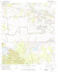 1972 Rapides1973 Print · USGSThe Red River valley in the early seventies shows a landscape of military expansion and hydraulic engineering. Trace the growth of England Air Force Base alongside historic sites like the Central Louisiana State Hospital and St Matthews Cem.3 unique versions available
 - 1972 Map of Woodworth East, 1974 Print
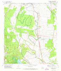 1972 Woodworth East1974 Print · USGSRapides Parish in the early seventies shows the expansion of southern Alexandria alongside the managed timber of the Alexander State Forest. Researchers can trace rural lineages at Oakland Ch Cem, find old rail stops at Moreland, or locate the Gravel Pit near Woodworth.3 unique versions available
 - 1972 Map of Alexandria, 1974 Print
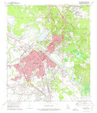 1972 Alexandria1974 Print · USGSAlexandria and Pineville sit at a major rail and river crossroads in the early seventies, just as the urban landscape was maturing. Local historians can trace the footprints of Camp Beauregard, the VA Hospital, and family-named landmarks like Pierson Lake and Lee Heights.4 unique versions available
End of results
Showing maps 1-3 of 3
Top cities near Alexandria
- Pineville historical maps
- Ball historical maps
- Colfax historical maps
- Lecompte historical maps
- Boyce historical maps
- Woodworth historical maps
See more
Top neighborhoods of Alexandria
- Samtown historical maps
- Alexandria Junction historical maps
- Kent historical maps
- Anandale historical maps
- Sieps historical maps
Frequently asked questions
- What are the different types of historical maps available for Alexandria?
- What is the oldest map of Alexandria?
- Where can I purchase historical maps of Alexandria for my home or office?
- Where can I download high-res historical maps of Alexandria?
- Are there historical topographic maps available for Alexandria?
- Is there historical aerial imagery available for Alexandria?
- Where are historical maps of Alexandria sourced from?