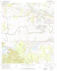
1972 Map of Rapides
USGS Topo · Published 1973About this map
England Air Force Base dominates the central landscape of this Louisiana survey, illustrating the significant military footprint near the Red River during the early 1970s. The map reveals a complex water management system where the Bayou Rapides snakes through the terrain alongside the newly forming Kincaid Reservoir, which shows blue hatching indicating areas destined for submergence. This era of transition is further marked by the proximity of the Central Louisiana State Hospital and the northern reaches of the Kisatchie National Forest. Local history is preserved through the locations of the Newlight Cem, St Matthews Ch, and the Rapides Sch, alongside industrial landmarks like the Fish Farm and the Texas and Pacific railroad lines that once served the rural settlements of Alfalfa and Weil.
Find a feature on this map
47 named features on this map. Tap any name to fly to it.
Don’t see what you’re looking for? This feature index may not catch every label — zoom into the map to look around manually.
Map Details
Editions of this 1972 Rapides Map
3 editions found
Other maps of this area

1932 · Boyce NE
USGS Topo · 1:31,680

1932 · Boyce SW
USGS Topo · 1:31,680

1935 · Lecompte
USGS Topo · 1:62,500

1941 · Alexandria
USGS Topo · 1:62,500

1941 · Boyce
USGS Topo · 1:62,500

1945 · Boyce SE
USGS Topo · 1:31,680

1949 · Boyce NW
USGS Topo · 1:31,680

1949 · Boyce SE
USGS Topo · 1:31,680

1953 · Alexandria
USGS Topo · 1:250,000

1955 · Alexandria
USGS Topo · 1:250,000