1990s Maps of Sabine Parish, Louisiana
Explore 9 historic maps of Sabine Parish from the 1990s. These maps offer a rare glimpse into what life looked like during the 1990s — showing old roads, neighborhoods, homes, and landmarks that have changed or disappeared over time.
Whether you're researching your family's past, planning a metal detecting trip, or studying how Sabine Parish's landscape evolved across the 1990s, these high-resolution maps are a powerful tool for exploring the history of this region.
- Focus on a specific era: All maps on this page are from the 1990s, giving you a focused view of this time period.
- See what’s changed: Compare century-old streets, trails, and buildings to today's modern landscape using overlays and satellite layers.
- Research with precision: Use these maps for genealogy, historical research, land use analysis, or educational projects.
- View, download, or print: Maps are fully viewable online in high resolution, and can be downloaded or printed for your own records.
Start exploring Sabine Parish's history through authentic maps from the 1990s. This is your window into the past.
Sabine Parish, LA maps
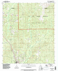
(9)- 1994 Map of Loring, 1996 Print
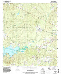 1994 Loring1996 Print · USGSIn the mid-1990s, the Sabine Parish backcountry showcased a blend of massive water projects and conservation lands. Genealogists and researchers can trace local landmarks like Loring, Edmondson, and the varied shoreline of the Toledo Bend Reservoir.
 - 1994 Map of Hornbeck, 1996 Print
 1994 Hornbeck1996 Print · USGSHornbeck and the surrounding parish line territory come into focus in the mid-nineties as the region's infrastructure expanded. Genealogists and researchers can locate family sites like Saint Lukes Cem and Beckham Cem or trace the winding course of Toro Bayou.
 - 1994 Map of Converse, 1996 Print
 1994 Converse1996 Print · USGSThe borderlands of De Soto and Sabine Parishes are captured here in the mid-1990s as a landscape of timberlands and bayous. Researchers can locate the small-town footprints of Converse and Benson or trace the winding course of San Patricio Bayou and Horsehead Creek.
 - 1994 Map of Belmont, 1997 Print
 1994 Belmont1997 Print · USGSSabine Parish in the mid-1990s was a landscape defined by deep timberlands and the winding waters of Bayou Scie. Researchers can trace the rural layout of Belmont and the northern fringes of Zwolle, or locate landmarks like Turpentine Spring and Beaverdam Slough.
 - 1994 Map of Many, 1997 Print
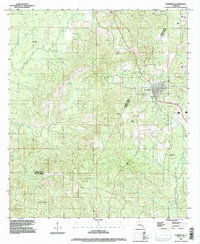
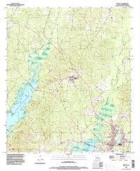
 1994 Many1997 Print · USGSSabine Parish and the town of Many are captured in the mid-nineties, showing a landscape of small settlements and timber-rich creek bottoms. Genealogists and historians can trace the grounds of Fort Jesup, the streets of Fisher, and the waters of Harpoon Bayou.
 - 1994 Map of Dowden Creek, 1997 Print
 1994 Dowden Creek1997 Print · USGSThe Fort Polk Military Reservation and Peason Ridge Artillery Range define this corner of Louisiana in the mid-1990s. Researchers can trace the drainage of Dowden Creek, locate the settlement of Anacoco, and see the early path of roads then Under Construction.
 - 1995 Map of Zwolle, 1997 Print
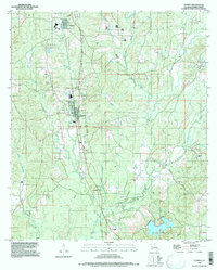
 1995 Zwolle1997 Print · USGSSabine Parish in the mid-1990s centers on the growing shoreline of the Toledo Bend Reservoir. Local researchers can trace family sites near Zwolle and Noble, or locate specific landmarks like the Clay Pit and numerous rural cemeteries.
 - 1997 Map of Florien
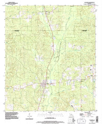
 1997 Florien1997 Print · USGSSabine Parish in the late nineties remains a landscape of timber-industry towns and quiet upland bayous. Genealogists and local historians can trace family locations through Sibley Cem, the small community of Grandy, and landmarks along Toro Bayou.
 - 1998 Map of Peason, 2003 Print
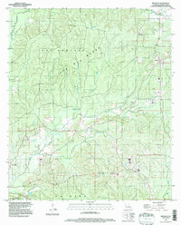
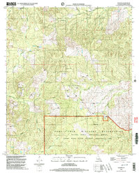 1998 Peason2003 Print · USGSSabine Parish at the end of the millennium shows the intersection of military training grounds and rural Louisiana life. Trace the boundaries of the Peason Ridge Artillery Range or locate landmarks like the Peason Fire Tower and Calvary Church.
End of results
Showing maps 1-9 of 9
Top cities of Sabine Parish
- Many historical maps
- Zwolle historical maps
- Pleasant Hill historical maps
- Florien historical maps
- Converse historical maps
- Fisher historical maps
See more
Frequently asked questions
- What are the different types of historical maps available for Sabine Parish?
- What is the oldest map of Sabine Parish?
- Where can I purchase historical maps of Sabine Parish for my home or office?
- Where can I download high-res historical maps of Sabine Parish?
- Are there historical topographic maps available for Sabine Parish?
- Is there historical aerial imagery available for Sabine Parish?
- Where are historical maps of Sabine Parish sourced from?