1940s Maps of Sabine Parish, Louisiana
Explore 19 historic maps of Sabine Parish from the 1940s. These maps offer a rare glimpse into what life looked like during the 1940s — showing old roads, neighborhoods, homes, and landmarks that have changed or disappeared over time.
Whether you're researching your family's past, planning a metal detecting trip, or studying how Sabine Parish's landscape evolved across the 1940s, these high-resolution maps are a powerful tool for exploring the history of this region.
- Focus on a specific era: All maps on this page are from the 1940s, giving you a focused view of this time period.
- See what’s changed: Compare century-old streets, trails, and buildings to today's modern landscape using overlays and satellite layers.
- Research with precision: Use these maps for genealogy, historical research, land use analysis, or educational projects.
- View, download, or print: Maps are fully viewable online in high resolution, and can be downloaded or printed for your own records.
Start exploring Sabine Parish's history through authentic maps from the 1940s. This is your window into the past.
Sabine Parish, LA maps
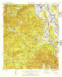
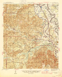
(19)- 1941 Map of Zwolle
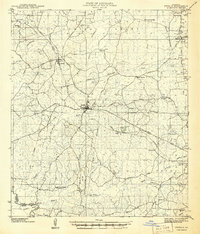 1941 Zwolle1941 Print · USGSSabine Parish in the early 1940s is captured here as a landscape of timber-driven rail lines and riverside crossings. Genealogists can trace the rural communities of the era through sites like Pattersons Ferry, Alliance Sch, and Sardis Cem.
 - 1941 Map of Pelican, 1942 Print
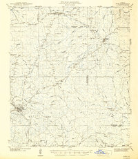
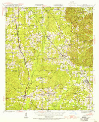
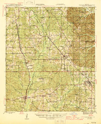
 1941 Pelican1942 Print · USGSDe Soto and Sabine Parishes are captured here in the early 1940s, when rail lines still drove the local economy. Researchers can locate family landmarks like Guy Cem, rural schoolhouses such as Pelican Sch, and the layout of the CCC Camp at Pleasant Hill.
 - 1942 Map of Many
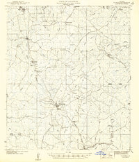
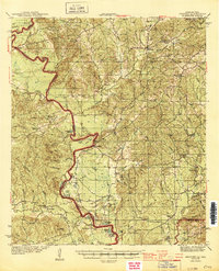
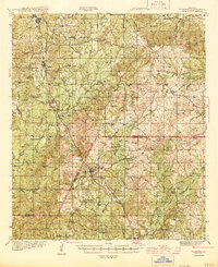
 1942 Many1942 Print · USGSSabine and Natchitoches Parishes are shown here in the early 1940s, a landscape defined by timber, railroads, and tight-knit rural communities. You can trace early family sites at Fort Jesup, find remote country schools like Armstrong Sch, and locate the CCC Camp.2 unique versions available
 - 1942 Map of Florien
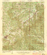
 1942 Florien1942 Print · USGSThe timber and rail corridor of the Louisiana pinewoods is captured here in the early 1940s as the Kansas City Southern railroad links small mill towns. Family historians can trace local roots through numerous rural landmarks like Sibley Cem, Mount Carmel, and Pine Grove Ch.
 - 1942 Map of Kisatchie
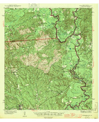
 1942 Kisatchie1942 Print · USGSThe timberlands of Natchitoches and Vernon Parishes are captured here in the early 1940s, showing the dense network of company towns and rail lines. Genealogists and researchers can locate timber settlements like Alco, Kurthwood, and Hutton, plus the CCC Camp and Silver Creek Church.
 - 1943 Map of Many
 1943 Many1943 Print · USGSSabine Parish during the early years of the war shows a landscape of timber camps and rail-dependent villages. Genealogists can trace family names through dozens of landmarks like Mt Carmel Cem, Fort Jesup, and the CCC Camp.
 - 1943 Map of Kisatchie
 1943 Kisatchie1943 Print · USGSDuring the early 1940s, this portion of Natchitoches Parish was a hive of timber activity centered around the Red River and Gulf Railroad. Researchers can trace old industry sites like Kurthwood and Alco or locate family sites at Robinson Cem and Kisatchie Union Ch.
 - 1943 Map of Provencal, 1954 Print
 1943 Provencal1954 Print · USGSNatchitoches Parish during the early 1940s reveals a landscape defined by the winding Red River and the Texas and Pacific RR. Genealogists can trace rural roots through landmarks like Friendship Cem, St Marks Ch, and the community at Bermuda.
 - 1943 Map of Pleasant Hill, 1955 Print
 1943 Pleasant Hill1955 Print · USGSNorthwest Louisiana's piney woods and bayous are documented here in the 1940s, a period when rural schools and railroad towns thrived. You can trace the path of the Texas and Pacific railroad through Pelican and locate family landmarks like Sebastian Cem and New Benson Sch.
 - 1944 Map of Negreet
 1944 Negreet1944 Print · USGSThe Sabine River valley at the height of the Second World War shows a landscape of river sloughs and forest communities before the arrival of the great reservoirs. Genealogists can trace family roots through numerous rural landmarks like Beulah Ch, Redland Cem, and the old Negreet School.
 - 1944 Map of Logansport
 1944 Logansport1944 Print · USGSDe Soto and Sabine Parishes are shown in the early 1940s as the Sabine River snakes through a landscape of bayous and forest. Genealogists and local historians can trace family roots through numerous sites like Prude Cem, Morning Glory Sch, and Pauls Store.
 - 1944 Map of Wiergate
 1944 Wiergate1944 Print · USGSNewton County and the Sabine River borderlands are captured here in the mid-1940s during the peak of the local timber era. Genealogists and researchers can trace family landmarks like Toledo Cem, the Gulf Northern rail line, and the rural Mayflower Sch.2 unique versions available
 - 1944 Map of Patroon
 1944 Patroon1944 Print · USGSThe Sabine River bottomlands at the Texas-Louisiana border come to life in this mid-century survey of Shelby County. Researchers can locate vanished landmarks like the Patroon CCC Camp, rural stores at Jordans Store, and local gathering places like Beech Grove Ch.2 unique versions available
 - 1944 Map of Florien
 1944 Florien1944 Print · USGSMid-century Sabine and Vernon Parishes center on the timber and rail economy along the Kansas City Southern. Genealogists can trace family roots through numerous rural landmarks like Lewing Cem, Plainview Sch, and Pratts Chapel.
 - 1944 Map of Zwolle
 1944 Zwolle1944 Print · USGSSabine Parish and the borderlands of Louisiana and Texas are captured here during the wartime economy. Family historians can locate rural landmarks like Noble Cem, Alliance Sch, and small community centers at Belmont and Vines.2 unique versions available
 - 1944 Map of Pleasant Hill
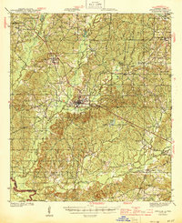
 1944 Pleasant Hill1944 Print · USGSDe Soto and Sabine Parishes are mapped here in the mid-1940s, showing a landscape defined by timber, small-scale farming, and rail transport. Genealogists can trace family landmarks like Stephenson Cem, Spring Hill Ch, and the rural community at Converse.
 - 1945 Map of Provencal
 1945 Provencal1945 Print · USGSNatchitoches Parish during the mid-1940s is defined by its complex network of waterways and the Texas and Pacific RR. Researchers can locate rural landmarks like Rockford Sch, Beasley Crossing, and the Bayou Gorum Post Office.
 - 1947 Map of Hanna
 1947 Hanna1947 Print · USGSRed River Parish and Natchitoches Parish are shown in the late 1940s, a period when the river valley remained a landscape of ferries, rural schools, and bayous. Genealogists can trace family landmarks like the Rambin Store, Jordon Ferry, and St James Cem.
 - 1948 Map of Wiergate, 1954 Print
 1948 Wiergate1954 Print · USGSThe Sabine River bottomlands and the timbered hills of Newton County are mapped here in the late 1940s. Genealogists and historians can trace rural life through landmarks like Anthonys Ferry, Scott Cem, and the old Sycamore Sch in the heart of the Sabine National Forest.
End of results
Showing maps 1-19 of 19
Top cities of Sabine Parish
- Many historical maps
- Zwolle historical maps
- Pleasant Hill historical maps
- Florien historical maps
- Converse historical maps
- Fisher historical maps
See more
Frequently asked questions
- What are the different types of historical maps available for Sabine Parish?
- What is the oldest map of Sabine Parish?
- Where can I purchase historical maps of Sabine Parish for my home or office?
- Where can I download high-res historical maps of Sabine Parish?
- Are there historical topographic maps available for Sabine Parish?
- Is there historical aerial imagery available for Sabine Parish?
- Where are historical maps of Sabine Parish sourced from?