1990s Maps of Saint Martin Parish, Louisiana
Explore 12 historic maps of Saint Martin Parish from the 1990s. These maps offer a rare glimpse into what life looked like during the 1990s — showing old roads, neighborhoods, homes, and landmarks that have changed or disappeared over time.
Whether you're researching your family's past, planning a metal detecting trip, or studying how Saint Martin Parish's landscape evolved across the 1990s, these high-resolution maps are a powerful tool for exploring the history of this region.
- Focus on a specific era: All maps on this page are from the 1990s, giving you a focused view of this time period.
- See what’s changed: Compare century-old streets, trails, and buildings to today's modern landscape using overlays and satellite layers.
- Research with precision: Use these maps for genealogy, historical research, land use analysis, or educational projects.
- View, download, or print: Maps are fully viewable online in high resolution, and can be downloaded or printed for your own records.
Start exploring Saint Martin Parish's history through authentic maps from the 1990s. This is your window into the past.
Saint Martin Parish, LA maps
(12)- 1992 Map of Grand River
 1992 Grand River1992 Print · USGSIberville and St. Martin Parishes are captured in the early nineties as a landscape defined by industrial energy and wetland management. Researchers can trace the massive Atchafalaya Basin Floodway alongside the Bayou Blue Oil and Gas Field and the settlement at Grand River.
 - 1992 Map of Maringouin
 1992 Maringouin1992 Print · USGSThe Atchafalaya Basin in the early nineties reveals a landscape split between the wild Atchafalaya National Wildlife Refuge and the industrial bayou towns. Researchers can trace family roots at New Zion Ch or explore the geography of the Maringouin Oil Field and the old Union Pacific line.
 - 1992 Map of Cow Bayou
 1992 Cow Bayou1992 Print · USGSThe Iberville and St. Martin Parish wetlands come alive in the early nineties, showing a landscape defined by the spillway and oil industry. Genealogists and historians can trace the intricate waterways of Billy Littles Lake, Cow Island, and the Henby Gas Field.
 - 1994 Map of Morgan City, 1998 Print
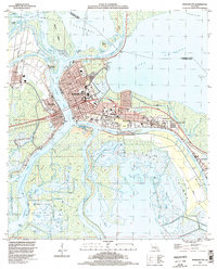 1994 Morgan City1998 Print · USGSThe Atchafalaya basin in the mid-1990s serves as a critical corridor for Louisiana's rail and water commerce. Researchers can trace the industrial footprint of Morgan City, the Southern Pacific rail lines, and local landmarks like Bradley Cem and Bayou Boeuf Lock.
 - 1994 Map of Centerville, 1998 Print
 1994 Centerville1998 Print · USGSThe riverine corridor of St. Mary Parish is captured here in the mid-1990s, where traditional settlements line the historic curves of the bayou. Researchers can locate family burial grounds like Caffery Cem and trace the proximity of Garden City to the Atchafalaya Basin Floodway.
 - 1994 Map of Amelia, 1998 Print
 1994 Amelia1998 Print · USGSCoastal Louisiana in the mid-nineties shows an intricate landscape of energy extraction and waterborne commerce centered on Amelia. Researchers can trace the industrial footprint of the Amelia Gas Field and locate local landmarks like St Andrews Cem and the Indian Mound.
 - 1998 Map of Breaux Bridge, 2000 Print
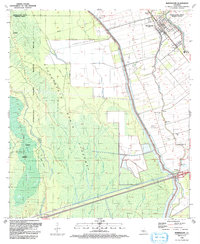
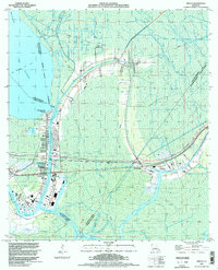
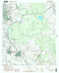
 1998 Breaux Bridge2000 Print · USGSBreaux Bridge and the surrounding Cajun heartland appear in the late nineties as a landscape defined by its historic bayous and oil industry. Researchers can trace family sites at St Bernard Cem or explore the old transport routes of the Old Railroad Grade and Bayou Teche.
 - 1998 Map of Cecilia, 2003 Print
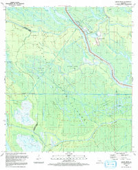
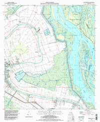
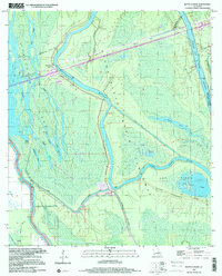
 1998 Cecilia2003 Print · USGSSt. Martin Parish in the late nineties shows a landscape balanced between Bayou Teche settlement and the Atchafalaya basin. Researchers can locate family landmarks like Our Lady of Mercy Cem or trace the early foundations of Nina Station and Henderson.
 - 1999 Map of Butte La Rose, 2000 Print
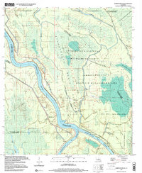
 1999 Butte La Rose2000 Print · USGSThe Atchafalaya Basin in the late twentieth century remains a labyrinth of waterways and small landings. Researchers can trace the river's path past Butte La Rose, locate the Atchafalaya Radio Tower, or explore the secluded reaches of Cow Island Lake and Lost Lake.
 - 1999 Map of Broussard, 2000 Print
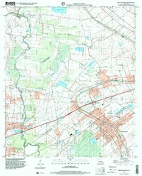
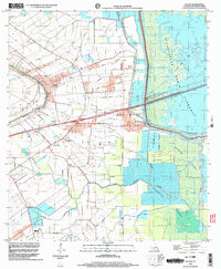
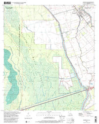
 1999 Broussard2000 Print · USGSThe Acadiana region at the close of the century shows the steady expansion of Lafayette toward the parish line. Researchers can trace local landmarks like the Holy Rosary Institute and settlements at Broussard, Billeaud, and Pilette.
 - 1999 Map of Maringouin NW, 2000 Print
 1999 Maringouin NW2000 Print · USGSThe Atchafalaya Basin at the close of the twentieth century reveals a landscape of industrial energy and protected wilderness. Researchers can trace the legacy of the Happytown Oil and Gas Field alongside the Atchafalaya River and Lake Comeaux.
 - 1999 Map of Maringouin, 2001 Print
 1999 Maringouin2001 Print · USGSIberville and Pointe Coupee parishes at the close of the century show a landscape defined by the Atchafalaya Basin Floodway and river commerce. Researchers can trace family sites at Shiloh Ch and West Oak Lane Cem or follow the UNION PACIFIC rail line through Musson.2 unique versions available
End of results
Showing maps 1-12 of 12
Top cities of Saint Martin Parish
Frequently asked questions
- What are the different types of historical maps available for Saint Martin Parish?
- What is the oldest map of Saint Martin Parish?
- Where can I purchase historical maps of Saint Martin Parish for my home or office?
- Where can I download high-res historical maps of Saint Martin Parish?
- Are there historical topographic maps available for Saint Martin Parish?
- Is there historical aerial imagery available for Saint Martin Parish?
- Where are historical maps of Saint Martin Parish sourced from?