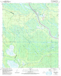
1992 Map of Grand River
USGS Topo · Published 1992About this map
The Atchafalaya Basin Floodway dominates this landscape, a complex network of wetlands and bayous defined by the extraction of natural resources in the early 1990s. Heavy industrial activity is evident through the extensive Bayou Blue Oil and Gas Field and Bayou Sorrel Oil and Gas Field, alongside a prominent Hazardous Waste Disposal Site located near the eastern levee. The settlement of Grand River and the nearby La Fayette mark the few established points of habitation in an area otherwise carved by a dense hydrological system including the West Fork Bayou Pigeon and East Fork Bayou Pigeon. The presence of numerous oil and gas fields, such as the Frog Lake Oil Field, illustrates the intersection of commercial energy infrastructure and the intricate drainage patterns of the Louisiana wetlands. Levee systems and gaging stations underscore the ongoing management of this flood-prone terrain.
Find a feature on this map
46 named features on this map. Tap any name to fly to it.
Don’t see what you’re looking for? This feature index may not catch every label — zoom into the map to look around manually.
Map Details
Editions of this 1992 Grand River Map
This is the sole edition of this map. No revisions or reprints were ever made.
Other maps of this area

1935 · Osca Bayou
USGS Topo · 1:62,500

1935 · Chicot Lake
USGS Topo · 1:62,500

1940 · Grosse Tete
USGS Topo · 1:62,500

1941 · Loreauville
USGS Topo · 1:62,500

1953 · Crescent
USGS Topo · 1:24,000

1953 · Cow Bayou
USGS Topo · 1:24,000

1953 · Pigeon Bay
USGS Topo · 1:24,000

1953 · Addis
USGS Topo · 1:24,000

1953 · Grosse Tete SW
USGS Topo · 1:24,000

1954 · Chicot Lake
USGS Topo · 1:62,500