1970s Maps of Krotz Springs, Louisiana
Explore 2 historic maps of Krotz Springs from the 1970s. These maps offer a rare glimpse into what life looked like during the 1970s — showing old roads, neighborhoods, homes, and landmarks that have changed or disappeared over time.
Whether you're researching your family's past, planning a metal detecting trip, or studying how Krotz Springs's landscape evolved across the 1970s, these high-resolution maps are a powerful tool for exploring the history of this region.
- Focus on a specific era: All maps on this page are from the 1970s, giving you a focused view of this time period.
- See what’s changed: Compare century-old streets, trails, and buildings to today's modern landscape using overlays and satellite layers.
- Research with precision: Use these maps for genealogy, historical research, land use analysis, or educational projects.
- View, download, or print: Maps are fully viewable online in high resolution, and can be downloaded or printed for your own records.
Start exploring Krotz Springs's history through authentic maps from the 1970s. This is your window into the past.
Krotz Springs, LA maps
(2)- 1970 Map of Fordoche, 1972 Print
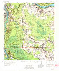 1970 Fordoche1972 Print · USGSPointe Coupee Parish in the early seventies reveals a landscape defined by massive flood control projects and a growing oil economy. Genealogists and historians can trace family locations near Stonewall Plantation, the Valverda Sch, or the Indian Mound Valley Cem.
 - 1970 Map of Palmetto, 1972 Print
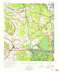 1970 Palmetto1972 Print · USGSSt. Landry and Pointe Coupee Parishes are shown in the early seventies as a landscape of deep bayous and massive flood control works. Genealogists and historians can trace family locations near Rideau Settlement, Palmetto Cem, and Sacred Heart Ch.
End of results
Showing maps 1-2 of 2
Top cities near Krotz Springs
- Breaux Bridge historical maps
- Port Barre historical maps
- Henderson historical maps
- Melville historical maps
- Livonia historical maps
- Arnaudville historical maps
See more
Frequently asked questions
- What are the different types of historical maps available for Krotz Springs?
- What is the oldest map of Krotz Springs?
- Where can I purchase historical maps of Krotz Springs for my home or office?
- Where can I download high-res historical maps of Krotz Springs?
- Are there historical topographic maps available for Krotz Springs?
- Is there historical aerial imagery available for Krotz Springs?
- Where are historical maps of Krotz Springs sourced from?