1960s Maps of Le Moyen, Louisiana
Explore 2 historic maps of Le Moyen from the 1960s. These maps offer a rare glimpse into what life looked like during the 1960s — showing old roads, neighborhoods, homes, and landmarks that have changed or disappeared over time.
Whether you're researching your family's past, planning a metal detecting trip, or studying how Le Moyen's landscape evolved across the 1960s, these high-resolution maps are a powerful tool for exploring the history of this region.
- Focus on a specific era: All maps on this page are from the 1960s, giving you a focused view of this time period.
- See what’s changed: Compare century-old streets, trails, and buildings to today's modern landscape using overlays and satellite layers.
- Research with precision: Use these maps for genealogy, historical research, land use analysis, or educational projects.
- View, download, or print: Maps are fully viewable online in high resolution, and can be downloaded or printed for your own records.
Start exploring Le Moyen's history through authentic maps from the 1960s. This is your window into the past.
Le Moyen, LA maps
(2)- 1965 Map of Morrow, 1967 Print
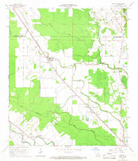 1965 Morrow1967 Print · USGSThe borderlands of St. Landry and Avoyelles Parishes were a grid of rail-side settlements and bayou-side farms in the mid-sixties. Local history researchers can trace the old rail corridors of the Texas and Pacific and locate rural landmarks like Lincoln Sch and Morrow Cem.2 unique versions available
 - 1966 Map of Bunkie, 1967 Print
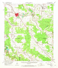 1966 Bunkie1967 Print · USGSBunkie and the surrounding bayou country are captured in the mid-1960s as the regional rail and oil economies flourished. Genealogists can locate family landmarks like Lincoln Sch, Snowden Cem, and the Morning Star Ch Cem near Evergreen.
End of results
Showing maps 1-2 of 2
Top cities near Le Moyen
- Opelousas historical maps
- Ville Platte historical maps
- Bunkie historical maps
- Port Barre historical maps
- Cottonport historical maps
- Simmesport historical maps
See more
Frequently asked questions
- What are the different types of historical maps available for Le Moyen?
- What is the oldest map of Le Moyen?
- Where can I purchase historical maps of Le Moyen for my home or office?
- Where can I download high-res historical maps of Le Moyen?
- Are there historical topographic maps available for Le Moyen?
- Is there historical aerial imagery available for Le Moyen?
- Where are historical maps of Le Moyen sourced from?