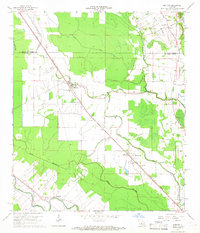
1965 Map of Morrow
USGS Topo · Published 1967About this map
Morrow and Big Cane anchor this mid-1960s landscape of the Atchafalaya basin's western edge, where agricultural fields are intricately divided by a network of bayous and rail lines. The Texas and Pacific railroad bisects the terrain diagonally, serving small communities like Le Moyen and Richards Spur, while the Southern Pacific tracks run through the southern corner near Rosa. This area demonstrates a dense distribution of rural institutions that served local families, including the Lincoln Sch, St Marks Ch, and Zion Traveler Ch.
Find a feature on this map
34 named features on this map. Tap any name to fly to it.
Don’t see what you’re looking for? This feature index may not catch every label — zoom into the map to look around manually.
Map Details
Editions of this 1965 Morrow Map
2 editions found
Other maps of this area

1939 · Opelousas
USGS Topo · 1:62,500

1948 · Bunkie
USGS Topo · 1:62,500

1952 · Lake Charles
USGS Topo · 1:250,000

1954 · Lake Charles
USGS Topo · 1:250,000

1954 · Baton Rouge
USGS Topo · 1:250,000

1955 · Odenburg
USGS Topo · 1:62,500

1956 · Opelousas
USGS Topo · 1:62,500

1956 · Baton Rouge
USGS Topo · 1:250,000

1957 · Opelousas
USGS Topo · 1:62,500

1959 · Palmetto
USGS Topo · 1:62,500