
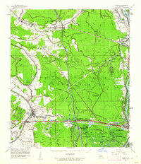
1959 Map of Palmetto
USGS Topo · Published 1962About this map
The Atchafalaya River corridor dominates this late-1950s landscape, illustrating the complex engineering required to manage the basin. Large-scale infrastructure like the Atchafalaya Floodway and several Drainage Structures define the relationship between the water and the land. Rail transport is central to the local economy, with the Texas and Pacific RR and Missouri Pacific RR serving established river towns and rail-line settlements.
Find a feature on this map
87 named features on this map. Tap any name to fly to it.
Don’t see what you’re looking for? This feature index may not catch every label — zoom into the map to look around manually.
Map Details
Editions of this 1959 Palmetto Map
2 editions found
Other maps of this area

1935 · Osca Bayou
USGS Topo · 1:62,500

1939 · Opelousas
USGS Topo · 1:62,500

1939 · Fordoche
USGS Topo · 1:62,500

1940 · Arnaudville
USGS Topo · 1:62,500

1941 · Batchelor
USGS Topo · 1:62,500

1948 · Bunkie
USGS Topo · 1:62,500

1952 · Lake Charles
USGS Topo · 1:250,000

1954 · Lake Charles
USGS Topo · 1:250,000

1954 · Baton Rouge
USGS Topo · 1:250,000

1955 · Osca Bayou
USGS Topo · 1:62,500