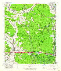
1959 Map of Palmetto
USGS Topo · Published 1962About this map
Bayou Teche and Bayou Courtableau dominate this mid-century landscape of the Atchafalaya Basin, where complex drainage systems and floodways define the local geography. The map illustrates the region just as the West Atchafalaya Floodway was a central fixture of the water management system, bounded by the Atchafalaya River. Small communities and agricultural clusters such as Palmetto, Rideau Settlement, and Lebeau are connected by the Missouri Pacific RR and Texas and Pacific RR. Local history is preserved through numerous family-named sites and religious centers, including Immaculate Conception Ch. & Sch., the Godeau Cem., and De Villier Cem.. This era also captures the intersection of traditional land use and industrial development, evident in the Port Barre Oil Field and the Krotz Springs Gas Field situated near the massive ST Landry Game Refuge No 1.
Find a feature on this map
80 named features on this map. Tap any name to fly to it.
Don’t see what you’re looking for? This feature index may not catch every label — zoom into the map to look around manually.
Map Details
Editions of this 1959 Palmetto Map
2 editions found

Other maps of this area

1935 · Osca Bayou
USGS Topo · 1:62,500

1939 · Opelousas
USGS Topo · 1:62,500

1939 · Fordoche
USGS Topo · 1:62,500

1940 · Arnaudville
USGS Topo · 1:62,500

1941 · Batchelor
USGS Topo · 1:62,500

1948 · Bunkie
USGS Topo · 1:62,500

1952 · Lake Charles
USGS Topo · 1:250,000

1954 · Lake Charles
USGS Topo · 1:250,000

1954 · Baton Rouge
USGS Topo · 1:250,000

1955 · Osca Bayou
USGS Topo · 1:62,500