Old Maps of St. Mary Parish, Louisiana for Academic Research
Study the evolution of St. Mary Parish with 231 high-resolution historic maps. Whether you're teaching, researching, or modeling changes in land use, these maps provide essential visual documentation of urban, environmental, and geographic change.
- Analyze long-term change: Track patterns in development, transportation, and natural features.
- Ideal for environmental or urban studies: Support academic projects with primary historical map data.
- Use in the classroom or lab: Educators and researchers rely on these maps to bring historical context to life.
These maps are a powerful tool for teaching, research, and visualizing how St. Mary Parish has changed over the decades.
St. Mary Parish, LA maps
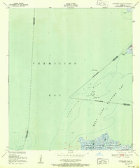
(231)- 1932 Map of Lake Decade
 1932 Lake Decade1932 Print · USGSCoastal Terrebonne Parish in the early thirties is a vast network of salt marshes and tidal bays just before the era of intensive coastal engineering. Genealogists and historians can trace isolated landmarks like Steinbergs Camp or navigate the intricate reaches of Rice Bayou and Lost Lake.
 - 1935 Map of Belle Isle
 1935 Belle Isle1935 Print · USGSThe Louisiana marshlands around Plaquemines Parish are captured in the mid-1930s, documenting a fragile coastal landscape of bayous and islands. Local historians can trace the early shoreline and navigation points like Telegraph Point, Stone Island, and Belle Isle.
 - 1935 Map of Morgan City
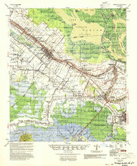
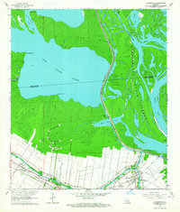
 1935 Morgan City1935 Print · USGSIn the mid-thirties, the Atchafalaya delta was a vital crossroads of the Old Spanish Trail and Southern Pacific rail lines. Genealogists and historians can trace family locations from Fairview Plantation to the Bradley Family Cem and the Bayou Black Settlement.
 - 1937 Map of Bayou Sale, 1949 Print
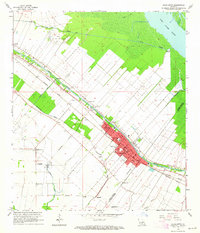
 1937 Bayou Sale1949 Print · USGSSt. Mary Parish during the late 1930s reveals a coastal world of rail-fed settlements and winding bayous. Researchers can trace family ties at the South Bend Cem, locate the Midway Ch & Sch, and follow the Southern Pacific tracks through Ellerslie.
 - 1937 Map of Jeanerette, 1949 Print
 1937 Jeanerette1949 Print · USGSCajun country comes alive in the late 1930s as plantations and rail lines dominate the banks of the Bayou Teche. Genealogists can trace family roots through numerous sites like St Nicholas Ch & Cem, the Rosenwald School, and the Bodin Plantation.
 - 1937 Map of Derouen, 1963 Print
 1937 Derouen1963 Print · USGSCoastal Louisiana in the late 1930s is revealed here as a landscape of salt domes and sugarcane plantations linked by rail and marsh. Genealogists and historians can trace family locations through Duboin Plantation, St Helens Church, and the settlement of Delcambre.
 - 1941 Map of Belle Isle, 1943 Print
 1941 Belle Isle1943 Print · USGSCoastal St. Mary Parish is shown here in the early 1940s during a period of significant hydraulic engineering and industrial shifts. Researchers can trace family sites at Little Zion Ch & Cem, the location of Plantation Fairfax, or the early Bateman Lake Oil Field.
 - 1945 Map of New Orleans
 1945 New Orleans1945 Print · USGSCoastal Louisiana and the Mississippi delta are captured here just after the war, showing the region's transition into a modern industrial and transit hub. Genealogists can trace family settlements along Bayou Teche or identify rail stops for the Illinois Central and Texas & Pacific lines.
 - 1948 Map of Foster, 1951 Print
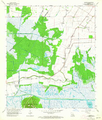
 1948 Foster1951 Print · USGSSt. Martin and St. Mary Parishes are shown at a post-war turning point, where Bayou Teche's plantation heritage meets the industrial era. Family historians can locate specific sites like Verdunville, Butler Ch & Cem, and the river-based community at Irish Bend.
 - 1948 Map of Cypremort Point, 1952 Print
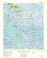
 1948 Cypremort Point1952 Print · USGSCoastal Louisiana in the late 1940s is defined here by the vast wetlands of Marsh Island and the open waters of the Gulf bays. Researchers can trace the early petroleum footprint at Oil well sites or locate the Conservation Camp near Bird I Bayou.2 unique versions available
 - 1949 Map of Cypremort Pt
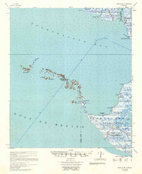
 1949 Cypremort Pt1949 Print · USGSThe Louisiana coast at the edge of St. Mary Parish is captured here during the late 1940s, showing a world of winding bayous and expansive bays. Researchers can trace the shifting shoreline near Cypremort Point, Oyster Lake, and the remote Dead Cypress Point.3 unique versions available
 - 1951 Map of Lake Point, 1952 Print
 1951 Lake Point1952 Print · USGSThe Louisiana coastline at the start of the 1950s reveals a vast network of wetlands and open water at the edge of Iberia Parish. Trace the early boundaries of the Russell Sage Foundation State Game Refuge and coastal landmarks like Lake Point and Tom Hawkins Bayou.2 unique versions available
 - 1953 Map of Napoleonville
 1953 Napoleonville1953 Print · USGSAssumption Parish sugar plantations and the emerging oil industry define this mid-century landscape. Researchers can trace historic family landholdings like Little Texas Plantation or follow the rail lines through Napoleonville and Paincourtville.2 unique versions available
 - 1954 Map of Morgan City
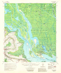
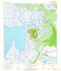
 1954 Morgan City1954 Print · USGSCoastal Louisiana in the mid-fifties shows a dynamic intersection of rail, road, and river traffic centered on the deep waters of Berwick Bay. Researchers can trace old family sites at Fairview Plantation, locate the Bayou L'Ourse Sch., or study the era's energy growth at the Bateman Lake Oil Field.
 - 1954 Map of Jeanerette
 1954 Jeanerette1954 Print · USGSCoastal Louisiana parishes are captured here in the mid-fifties, where the bayou-based economy met the rising oil and gas industries. Researchers can trace family sites at St Peters Ch & Cem, explore the reaches of Grand Lake, or locate the Jeanerette Airfield.
 - 1954 Map of Belle Isle
 1954 Belle Isle1954 Print · USGSThe Louisiana bayou country of St. Mary Parish is captured in the mid-1950s, showing a landscape defined by plantation history and new industrial growth. Genealogists can locate family landmarks like Waveland Plantation, Jerusalem Church, and the North Bend Cemetery.
 - 1957 Map of Lake Decade
 1957 Lake Decade1957 Print · USGSCoastal Louisiana marshes in the late fifties reveal an intricate network of tidewater bayous and emerging energy infrastructure. Researchers can trace the early footprints of the Deer Island Gas Field and locate remote maritime features like the Shrimp Platform and Mosquito Point Lt.2 unique versions available
 - 1957 Map of Bayou Sale
 1957 Bayou Sale1957 Print · USGSCoastal St. Mary Parish is seen here in the late fifties, showcasing the complex relationship between the petroleum industry and the gulf marshland. Genealogists and historians can trace old bayou settlements like South Bend and Ellerslie, or locate the South Bend Cem amidst the Bayou Sale Oil Field.
 - 1957 Map of Point Au Fer
 1957 Point Au Fer1957 Print · USGSThe coastal marshes of South Louisiana are captured here during the mid-fifties as the oil industry began to mark the landscape. Researchers can trace the development of the Point au Fer Oil Field or locate coastal landmarks like Pelican Battery and Two Oaks.
 - 1959 Map of Foster, 1960 Print
 1959 Foster1960 Print · USGSCoastal Louisiana at the close of the 1950s shows a fascinating transition from traditional river life to a burgeoning energy economy. Researchers can trace family roots through the Israelite Cem and Evening Star Church or locate historic estates like Oaklawn Manor along Bayou Teche.3 unique versions available
 - 1963 Map of New Orleans
 1963 New Orleans1963 Print · USGSCoastal Louisiana in the mid-twentieth century reveals a complex world of bayou settlements, expanding oil fields, and vital rail networks. Genealogists and historians can trace family roots through river towns like Thibodaux or follow the Southern Pacific line through Franklin and Patterson.4 unique versions available
 - 1963 Map of Weeks, 1964 Print
 1963 Weeks1964 Print · USGSThe coastal marsh of Iberia Parish is shown here in the early sixties, centered on the unique industrial topography of Weeks Island. Researchers can trace the development of the Weeks Island Oil and Gas Field and locate local landmarks like the Pentecostal Ch and Ewing Cem.4 unique versions available
 - 1963 Map of Charenton, 1964 Print
 1963 Charenton1964 Print · USGSThe Bayou Teche corridor and the edge of the Atchafalaya Basin are captured here in the early sixties. Genealogists and local historians can trace family locations near Charenton, Sorrel, and the Mt Pleasant Ch alongside the Southern Pacific tracks.3 unique versions available
 - 1963 Map of Jeanerette, 1964 Print
 1963 Jeanerette1964 Print · USGSCoastal Iberia Parish in the early sixties reveals a landscape shaped by Bayou Teche and the regional oil industry. Genealogists and historians can trace family roots through the dense network of Hubertville, Patoutville, and Boynton Cemetery.2 unique versions available
 - 1963 Map of Kemper, 1964 Print
 1963 Kemper1964 Print · USGSCoastal St. Mary Parish in the early sixties reveals a landscape shaped by sugar plantations and the railroad. Researchers can trace family sites from Kilgore Plantation to Freetown and locate landmarks like Gibbs Sch and the ferry crossing the Intracoastal Waterway.2 unique versions available
Showing maps 1-25 of 231
Top cities of St. Mary Parish
- Morgan City historical maps
- Franklin historical maps
- Patterson historical maps
- Berwick historical maps
- Bayou Vista historical maps
- Baldwin historical maps
See more
Frequently asked questions
- What are the different types of historical maps available for St. Mary Parish?
- What is the oldest map of St. Mary Parish?
- Where can I purchase historical maps of St. Mary Parish for my home or office?
- Where can I download high-res historical maps of St. Mary Parish?
- Are there historical topographic maps available for St. Mary Parish?
- Is there historical aerial imagery available for St. Mary Parish?
- Where are historical maps of St. Mary Parish sourced from?