1960s Maps of St. Mary Parish, Louisiana
Explore 27 historic maps of St. Mary Parish from the 1960s. These maps offer a rare glimpse into what life looked like during the 1960s — showing old roads, neighborhoods, homes, and landmarks that have changed or disappeared over time.
Whether you're researching your family's past, planning a metal detecting trip, or studying how St. Mary Parish's landscape evolved across the 1960s, these high-resolution maps are a powerful tool for exploring the history of this region.
- Focus on a specific era: All maps on this page are from the 1960s, giving you a focused view of this time period.
- See what’s changed: Compare century-old streets, trails, and buildings to today's modern landscape using overlays and satellite layers.
- Research with precision: Use these maps for genealogy, historical research, land use analysis, or educational projects.
- View, download, or print: Maps are fully viewable online in high resolution, and can be downloaded or printed for your own records.
Start exploring St. Mary Parish's history through authentic maps from the 1960s. This is your window into the past.
St. Mary Parish, LA maps
(27)- 1963 Map of New Orleans
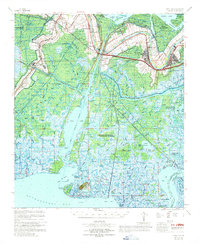
 1963 New Orleans1963 Print · USGSCoastal Louisiana in the mid-twentieth century reveals a complex world of bayou settlements, expanding oil fields, and vital rail networks. Genealogists and historians can trace family roots through river towns like Thibodaux or follow the Southern Pacific line through Franklin and Patterson.4 unique versions available
 - 1963 Map of Weeks, 1964 Print
 1963 Weeks1964 Print · USGSThe coastal marsh of Iberia Parish is shown here in the early sixties, centered on the unique industrial topography of Weeks Island. Researchers can trace the development of the Weeks Island Oil and Gas Field and locate local landmarks like the Pentecostal Ch and Ewing Cem.4 unique versions available
 - 1963 Map of Charenton, 1964 Print
 1963 Charenton1964 Print · USGSThe Bayou Teche corridor and the edge of the Atchafalaya Basin are captured here in the early sixties. Genealogists and local historians can trace family locations near Charenton, Sorrel, and the Mt Pleasant Ch alongside the Southern Pacific tracks.3 unique versions available
 - 1963 Map of Jeanerette, 1964 Print
 1963 Jeanerette1964 Print · USGSCoastal Iberia Parish in the early sixties reveals a landscape shaped by Bayou Teche and the regional oil industry. Genealogists and historians can trace family roots through the dense network of Hubertville, Patoutville, and Boynton Cemetery.2 unique versions available
 - 1963 Map of Kemper, 1964 Print
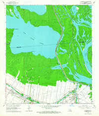
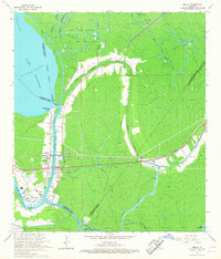
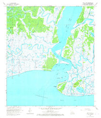
 1963 Kemper1964 Print · USGSCoastal St. Mary Parish in the early sixties reveals a landscape shaped by sugar plantations and the railroad. Researchers can trace family sites from Kilgore Plantation to Freetown and locate landmarks like Gibbs Sch and the ferry crossing the Intracoastal Waterway.2 unique versions available
 - 1963 Map of Franklin, 1964 Print
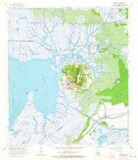
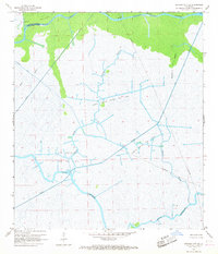
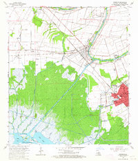 1963 Franklin1964 Print · USGSCoastal St. Mary Parish in the early sixties reveals a landscape shaped by the sugar industry and the growing oil fields. Genealogists can locate family landmarks like Bodin Plantation, the Nazarene Church, and schools including Crowell School and Hanson School.3 unique versions available
 - 1963 Map of Jeanerette, 1967 Print
 1963 Jeanerette1967 Print · USGSCajun country comes alive in the mid-1960s as settlement clusters along the banks of Bayou Teche and the edge of the Atchafalaya. Genealogists and historians can trace legacy sites from Kilgore Plantation to the streets of Jeanerette and Baldwin.2 unique versions available
 - 1963 Map of Derouen, 1968 Print
 1963 Derouen1968 Print · USGSCoastal Iberia Parish comes into focus during the early 1960s, showing the intersection of salt dome industry and traditional bayou life. Genealogists and researchers can trace family lands near Duboin Plantation, New Iberia, and the historic St Joseph Cem.
 - 1966 Map of Derouen
 1966 Derouen1966 Print · USGSThe coastal marshlands and industrial salt domes of South Louisiana are captured here in the mid-1960s. Genealogists and local historians can trace family-named sites like Broussville and Migues, or explore industrial landmarks at Avery Island and the Port of New Iberia.
 - 1966 Map of New Orleans
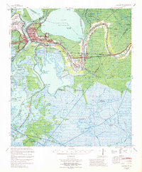
 1966 New Orleans1966 Print · USGSCoastal Louisiana in the mid-1960s reveals a transition from traditional bayou life to an intensive offshore oil and gas economy. Researchers can trace the rail lines of the Southern Pacific RR through Morgan City or locate the Eugene Island Lighthouse among the delta's shifting marshes.
 - 1966 Map of Morgan City, 1967 Print
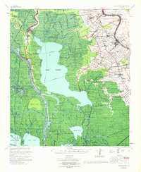
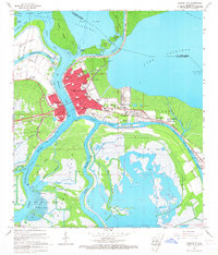 1966 Morgan City1967 Print · USGSCoastal Louisiana at the height of its mid-century energy boom centers on the vital shipping hub of Morgan City. Researchers can trace the development of small communities like Siracusaville and locate local landmarks such as Bradley Cem and the Lake End Park.2 unique versions available
 - 1966 Map of Lake Salve, 1967 Print
 1966 Lake Salve1967 Print · USGSCoastal Louisiana marshes in the mid-1960s reveal a landscape dominated by winding waterways and industrial reach. Trace the intricate bayous and hammocks of the Atchafalaya basin, from the waters of Lake Salve to landmarks like Live Oak Hammock and Shell Island.3 unique versions available
 - 1966 Map of Amelia, 1967 Print
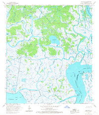
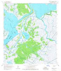
 1966 Amelia1967 Print · USGSCoastal St. Mary Parish thrived at the intersection of energy production and water transport during the mid-sixties. Genealogists and industrial historians can trace the development of Amelia and Boeuf alongside landmarks like St Andrews Cem and the Amelia Airport.3 unique versions available
 - 1966 Map of Napoleonville SW, 1967 Print
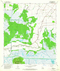
 1966 Napoleonville SW1967 Print · USGSSt. Martin Parish in the mid-sixties reveals a working landscape of bayous and basins where the river economy met emerging industry. Trace the settlement at Stephenville and explore the industrial footprint of the West Lake Verret Oil and Gas Field.4 unique versions available
 - 1966 Map of Morgan City SW, 1967 Print
 1966 Morgan City SW1967 Print · USGSThe coastal marshes of Terrebonne Parish are captured in the mid-1960s, showing a landscape defined by the Lower Atchafalaya River and early energy exploration. Researchers can trace the extensive network of waterways like Chene Bayou and the industrial infrastructure of the Bateman Lake Gas and Oil Field.2 unique versions available
 - 1966 Map of Patterson, 1967 Print
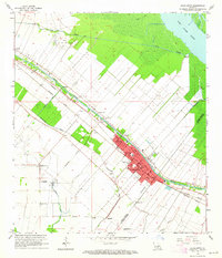
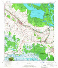
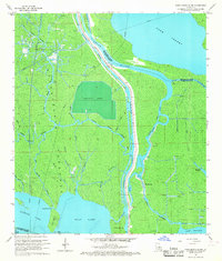
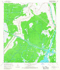
 1966 Patterson1967 Print · USGSThe St. Mary Parish wetlands come alive in the mid-1960s as the river-and-rail economy thrives along the Bayou Teche. Genealogists and historians can trace the footprints of Patterson, Calumet, and Lagonda alongside the Southern Pacific tracks.4 unique versions available
 - 1966 Map of Belle Isle, 1967 Print
 1966 Belle Isle1967 Print · USGSCoastal Louisiana in the mid-sixties reveals a landscape of industrial energy and complex marshland hydrology. Researchers can trace the layout of the Big Wax Gas and Oil Field and locate landmarks like Belle Isle Point and Negro Hammock.3 unique versions available
 - 1966 Map of Morgan City SE, 1967 Print
 1966 Morgan City SE1967 Print · USGSCoastal Terrebonne Parish in the mid-sixties reveals an intricate marshland landscape shaped by the emerging energy industry. Researchers can trace the extensive pipeline networks and the development of the North Turtle Bayou Gas Field and Bayou Penchant.4 unique versions available
 - 1966 Map of North Bend, 1967 Print
 1966 North Bend1967 Print · USGSCoastal Louisiana in the 1960s reveals a world shaped by the oil industry and deep-seated local settlements. Genealogists and historians can trace family ties at North Bend, Midway, and Little Zion Ch, while mapping the industrial footprint of the Southern Pacific railroad.3 unique versions available
 - 1967 Map of Napoleonville, 1969 Print
 1967 Napoleonville1969 Print · USGSThe Louisiana bayous and wetlands of Assumption and St. Martin Parishes are captured here in the late sixties during a period of transition for the oil and gas industries. Genealogists and historians can trace family-named settlements like Stephenville and Pierre Part or locate St. Benedict School and the Sacred Heart Church.
 - 1967 Map of Belle Isle, 1969 Print
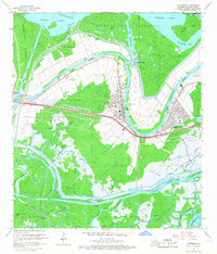
 1967 Belle Isle1969 Print · USGSThe coastal marshlands and bayou communities of St. Mary Parish are captured in the late sixties as the region's oil and gas industry matured. Researchers can trace family sites and industrial landmarks from Patterson to the Belle Isle Gas and Oil Field or the Little Zion Church.
 - 1967 Map of Morgan City, 1969 Print
 1967 Morgan City1969 Print · USGSThe Atchafalaya River and Intracoastal Waterway intersect at Louisiana's offshore industrial heart during the late sixties. Genealogists and historians can locate Morgan City landmarks, Berwick High School, and smaller settlements like Siracusaville or Amelia.
 - 1968 Map of Hammock Lake, 1969 Print
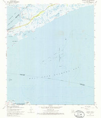 1968 Hammock Lake1969 Print · USGSCoastal St. Mary Parish in the late sixties shows a landscape of tidal marshes and emerging offshore industry. Genealogists and maritime researchers can trace the shoreline through Cypremort Point Beach, Quintana, and the Shark Bayou wetlands.2 unique versions available
 - 1968 Map of Cypremort Point, 1970 Print
 1968 Cypremort Point1970 Print · USGSThe Iberia Parish coastline at the end of the 1960s reveals a landscape of industrial extraction and environmental preservation. Trace the mid-century development of the Cypremort Point settlement and the Oil and Gas Field alongside Marsh Island.2 unique versions available
 - 1968 Map of Marsh Island, 1970 Print
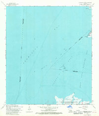
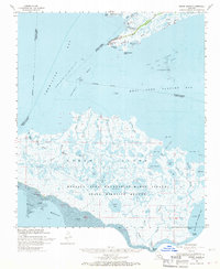 1968 Marsh Island1970 Print · USGSCoastal Louisiana marshes and offshore oil fields define this region in the late sixties. Naturalists and researchers can trace the intricate waterways of the Marsh Island State Wildlife Refuge and locate remote sites like the Conservation Camp or Cypremort Point.2 unique versions available
Showing maps 1-25 of 27
Top cities of St. Mary Parish
- Morgan City historical maps
- Franklin historical maps
- Patterson historical maps
- Berwick historical maps
- Bayou Vista historical maps
- Baldwin historical maps
See more
Frequently asked questions
- What are the different types of historical maps available for St. Mary Parish?
- What is the oldest map of St. Mary Parish?
- Where can I purchase historical maps of St. Mary Parish for my home or office?
- Where can I download high-res historical maps of St. Mary Parish?
- Are there historical topographic maps available for St. Mary Parish?
- Is there historical aerial imagery available for St. Mary Parish?
- Where are historical maps of St. Mary Parish sourced from?