1960s Maps of Mandeville, Louisiana
Explore 6 historic maps of Mandeville from the 1960s. These maps offer a rare glimpse into what life looked like during the 1960s — showing old roads, neighborhoods, homes, and landmarks that have changed or disappeared over time.
Whether you're researching your family's past, planning a metal detecting trip, or studying how Mandeville's landscape evolved across the 1960s, these high-resolution maps are a powerful tool for exploring the history of this region.
- Focus on a specific era: All maps on this page are from the 1960s, giving you a focused view of this time period.
- See what’s changed: Compare century-old streets, trails, and buildings to today's modern landscape using overlays and satellite layers.
- Research with precision: Use these maps for genealogy, historical research, land use analysis, or educational projects.
- View, download, or print: Maps are fully viewable online in high resolution, and can be downloaded or printed for your own records.
Start exploring Mandeville's history through authentic maps from the 1960s. This is your window into the past.
Mandeville, LA maps
(6)- 1961 Map of Baton Rouge, 1966 Print
 1961 Baton Rouge1966 Print · USGSSoutheastern Louisiana in the early sixties remains a landscape of deep river bends and sprawling coastal lakes. Genealogists and historians can trace the rail-and-river economy through landmarks like Free-Nigger Point, Donaldsonville, and the Illinois Central Railroad.
 - 1962 Map of Baton Rouge
 1962 Baton Rouge1962 Print · USGSSouth Louisiana in the early sixties reveals a landscape of river-bend parishes and emerging interstate corridors. Genealogists and historians can trace family roots through historic river towns like Donaldsonville and Plaquemine, or follow the path of the Illinois Central Railroad through the swamp basins.
 - 1968 Map of Covington, 1969 Print
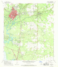 1968 Covington1969 Print · USGSNorth of Lake Pontchartrain in the late sixties, the landscape around COVINGTON and Mandeville shows a mix of riverfront settlement and woodland institutions. Genealogists can trace family landmarks like Wilson Cem, Chinchuba Cem, and the Rosenwald Sch at the height of the railroad era.4 unique versions available
 - 1968 Map of Madisonville, 1969 Print
 1968 Madisonville1969 Print · USGSThe Tchefuncta River basin in the late sixties shows a transition from traditional river life to modern parish growth. Genealogists and local researchers can locate numerous historical burial sites and landmarks like Rosenwald Sch Cem, Penns Chapel, and Goodbee.4 unique versions available
 - 1968 Map of Mandeville, 1969 Print
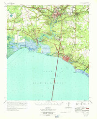
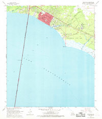 1968 Mandeville1969 Print · USGSMandeville and the northern shore of Lake Pontchartrain appear here in the late sixties as the area grew around its traditional bayou boundaries. Researchers can trace the layout of local schools like Rosenwald Sch or locate the historic Southeast Louisiana Hospital and Lewisburg waterfront.5 unique versions available
 - 1969 Map of Covington, 1971 Print
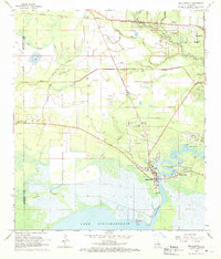
 1969 Covington1971 Print · USGSSt. Tammany Parish's north shore of Lake Pontchartrain is shown in detail during the late sixties. Trace the development of Covington and Mandeville, or locate family sites like Daussin Cem and White Chapel.
End of results
Showing maps 1-6 of 6
Top cities near Mandeville
- New Orleans historical maps
- Covington historical maps
- Abita Springs historical maps
- Madisonville historical maps
Top neighborhoods of Mandeville
Frequently asked questions
- What are the different types of historical maps available for Mandeville?
- What is the oldest map of Mandeville?
- Where can I purchase historical maps of Mandeville for my home or office?
- Where can I download high-res historical maps of Mandeville?
- Are there historical topographic maps available for Mandeville?
- Is there historical aerial imagery available for Mandeville?
- Where are historical maps of Mandeville sourced from?