1990s Maps of Mandeville, Louisiana
Explore 4 historic maps of Mandeville from the 1990s. These maps offer a rare glimpse into what life looked like during the 1990s — showing old roads, neighborhoods, homes, and landmarks that have changed or disappeared over time.
Whether you're researching your family's past, planning a metal detecting trip, or studying how Mandeville's landscape evolved across the 1990s, these high-resolution maps are a powerful tool for exploring the history of this region.
- Focus on a specific era: All maps on this page are from the 1990s, giving you a focused view of this time period.
- See what’s changed: Compare century-old streets, trails, and buildings to today's modern landscape using overlays and satellite layers.
- Research with precision: Use these maps for genealogy, historical research, land use analysis, or educational projects.
- View, download, or print: Maps are fully viewable online in high resolution, and can be downloaded or printed for your own records.
Start exploring Mandeville's history through authentic maps from the 1990s. This is your window into the past.
Mandeville, LA maps
(4)- 1998 Map of Madisonville, 2001 Print
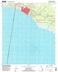
 1998 Madisonville2001 Print · USGSThe lower Tchefuncta River and the shores of Lake Pontchartrain define this late-century landscape. Genealogists and historians can trace family roots at Helping Hands Cem, find the site of the Rosenwald Sch, or follow the Old Railroad Grade.
 - 1998 Map of Mandeville, 2001 Print
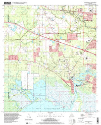
 1998 Mandeville2001 Print · USGSMandeville and the St. Tammany Parish shoreline are captured here at the close of the twentieth century. Genealogists and local historians can trace residential growth around Our Lady of the Lake Sch, the grounds of the Southeast Louisiana State Hospital, and the early path of the Lake Pontchartrain Causeway.
 - 1998 Map of Covington, 2002 Print
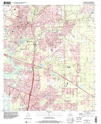 1998 Covington2002 Print · USGSSt. Tammany Parish at the end of the century shows the growing footprints of Covington and Mandeville alongside deep-rooted rural landmarks. Trace family history at Lyons Sch Wilson Cem or locate community centers like Rose Hill Ch and St Pauls College.
 - 1999 Map of Mandeville, 2000 Print
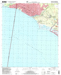
 1999 Mandeville2000 Print · USGSThe north shore of Lake Pontchartrain comes into focus at the turn of the millennium, showing a established coastal community and its surrounding marshlands. Genealogists can locate family landmarks like the Rosenwald Sch, Lewisburg, and the Southeast Louisiana State Hospital.
End of results
Showing maps 1-4 of 4
Top cities near Mandeville
- New Orleans historical maps
- Covington historical maps
- Abita Springs historical maps
- Madisonville historical maps
Top neighborhoods of Mandeville
Frequently asked questions
- What are the different types of historical maps available for Mandeville?
- What is the oldest map of Mandeville?
- Where can I purchase historical maps of Mandeville for my home or office?
- Where can I download high-res historical maps of Mandeville?
- Are there historical topographic maps available for Mandeville?
- Is there historical aerial imagery available for Mandeville?
- Where are historical maps of Mandeville sourced from?