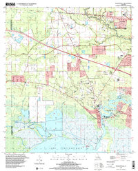
1998 Map of Madisonville
USGS Topo · Published 2001About this map
The Tchefuncta River winds toward its mouth at Lake Pontchartrain, anchoring the historic port of Madisonville and the nearby community of Houltonville. This landscape reflects the deep history of St. Tammany Parish, where river navigation and overland transport intersected. An Old Railroad Grade cuts across the northern terrain near Goodbee, marking the path of former timber or regional rail lines that once fueled the local economy.
Find a feature on this map
37 named features on this map. Tap any name to fly to it.
Don’t see what you’re looking for? This feature index may not catch every label — zoom into the map to look around manually.
Map Details
Editions of this 1998 Madisonville Map
This is the sole edition of this map. No revisions or reprints were ever made.
Other maps of this area

1935 · Covington
USGS Topo · 1:62,500

1935 · Ponchatoula
USGS Topo · 1:62,500

1939 · Ponchatoula
USGS Topo · 1:62,500

1939 · Covington
USGS Topo · 1:62,500

1942 · Onville
USGS Topo · 1:31,680

1942 · Waldheim
USGS Topo · 1:31,680

1942 · Robert
USGS Topo · 1:31,680

1950 · Covington
USGS Topo · 1:62,500

1951 · Ponchatoula
USGS Topo · 1:62,500

1954 · Folsom
USGS Topo · 1:62,500