1960s Maps of Waterproof, Louisiana
Explore 3 historic maps of Waterproof from the 1960s. These maps offer a rare glimpse into what life looked like during the 1960s — showing old roads, neighborhoods, homes, and landmarks that have changed or disappeared over time.
Whether you're researching your family's past, planning a metal detecting trip, or studying how Waterproof's landscape evolved across the 1960s, these high-resolution maps are a powerful tool for exploring the history of this region.
- Focus on a specific era: All maps on this page are from the 1960s, giving you a focused view of this time period.
- See what’s changed: Compare century-old streets, trails, and buildings to today's modern landscape using overlays and satellite layers.
- Research with precision: Use these maps for genealogy, historical research, land use analysis, or educational projects.
- View, download, or print: Maps are fully viewable online in high resolution, and can be downloaded or printed for your own records.
Start exploring Waterproof's history through authentic maps from the 1960s. This is your window into the past.
Waterproof, LA maps
(3)- 1963 Map of Chamblee, 1964 Print
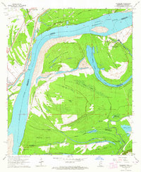 1963 Chamblee1964 Print · USGSThe Mississippi River's shifting bends and cutoffs in the early 1960s reveal a landscape of islands and oil fields along the Louisiana-Mississippi border. Genealogists and historians can trace the locations of Durango Plantation, Myrtle Grove Cem, and the village of Chamblee.2 unique versions available
 - 1963 Map of Waterproof, 1964 Print
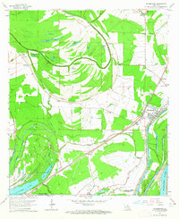 1963 Waterproof1964 Print · USGSNortheastern Louisiana in the 1960s was a landscape shaped by its river systems and agricultural heritage. Researchers can trace family roots through the Arcola and Winona estates or locate community landmarks like Richland Ch and Waterproof.2 unique versions available
 - 1965 Map of Locust Ridge, 1967 Print
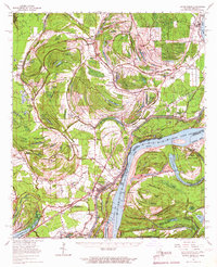 1965 Locust Ridge1967 Print · USGSThe Louisiana-Mississippi riverlands are captured here in the mid-1960s, showing the intricate oxbow lakes and rail-connected settlements along the river's edge. Researchers can locate family-named estates like Winona Plantation and rural landmarks like Choctaw Chapel and the Shiloh Ch.2 unique versions available
End of results
Showing maps 1-3 of 3
Top cities near Waterproof
- Natchez historical maps
- Ferriday historical maps
- Saint Joseph historical maps
- Ridgecrest historical maps
- Clayton historical maps
Frequently asked questions
- What are the different types of historical maps available for Waterproof?
- What is the oldest map of Waterproof?
- Where can I purchase historical maps of Waterproof for my home or office?
- Where can I download high-res historical maps of Waterproof?
- Are there historical topographic maps available for Waterproof?
- Is there historical aerial imagery available for Waterproof?
- Where are historical maps of Waterproof sourced from?