Old Maps of Theriot, Louisiana for Genealogy
Trace your family roots with 17 historic maps of Theriot. These high-res maps reveal old neighborhoods, homesites, landmarks, and streets — helping you uncover where your ancestors lived and how the area evolved over time.
- Explore historic neighborhoods: Identify where your relatives may have lived in the 1800s or 1900s.
- Compare maps over time: Trace the changes in streets, buildings, and landmarks for multi-generational research.
- Perfect for genealogy & ancestry research: Used by family historians and researchers to map out lineage and migration.
These maps are an incredible resource for exploring your personal connection to Theriot's past.
Theriot, LA maps
(17)- 1894 Map of Bayou De Large
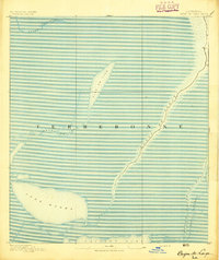 1894 Bayou De Large1894 Print · USGSCoastal Louisiana at the end of the nineteenth century reveals a landscape defined by its shifting bayous and vast interior lakes. Researchers can trace early settlement patterns along Bayou De Large and locate landmarks like Lake Washa and Bayou Grand Caillou.4 unique versions available
 - 1935 Map of Theriot
 1935 Theriot1935 Print · USGSTerrebonne Parish’s coastal marshes and bayou communities are detailed here during the mid-1930s. Genealogists and local historians can trace the early drainage and transit network through the Marmande Canal, Theriot P O, and an ancient Indian Mound.
 - 1940 Map of Bayou Du Large, 1962 Print
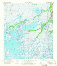
 1940 Bayou Du Large1962 Print · USGSCoastal Terrebonne Parish appears here as it was surveyed just before the war, a landscape of intricate bayous and expansive lakes. Genealogists and researchers can trace local settlements and landmarks like Theriot, St Andrews Ch, and the remote Bourgs Camp.
 - 1941 Map of Bayou Du Large
 1941 Bayou Du Large1941 Print · USGSCoastal Terrebonne Parish in the early 1940s is a landscape of expansive lakes and narrow bayou ridges. Genealogists and local historians can trace the community life of Theriot and locate landmarks like Johnson Ch, St Andrews Ch, and an ancient Indian Mound.
 - 1944 Map of Bayou Du Large
 1944 Bayou Du Large1944 Print · USGSThe marshes and ridges of Terrebonne Parish come alive in this mid-century survey of the coastal bayous. Genealogists and historians can trace family locations along Bayou Du Large, identifying landmarks like St Andrews Ch, Theriot, and Indian Mound.
 - 1945 Map of New Orleans
 1945 New Orleans1945 Print · USGSCoastal Louisiana and the Mississippi delta are captured here just after the war, showing the region's transition into a modern industrial and transit hub. Genealogists can trace family settlements along Bayou Teche or identify rail stops for the Illinois Central and Texas & Pacific lines.
 - 1963 Map of New Orleans
 1963 New Orleans1963 Print · USGSCoastal Louisiana in the mid-twentieth century reveals a complex world of bayou settlements, expanding oil fields, and vital rail networks. Genealogists and historians can trace family roots through river towns like Thibodaux or follow the Southern Pacific line through Franklin and Patterson.4 unique versions available
 - 1964 Map of Bayou Du Large, 1965 Print
 1964 Bayou Du Large1965 Print · USGSCoastal Louisiana marshlands in the mid-1960s reveal a landscape of ridges and bayous defined by water-borne industry and isolated settlements. Researchers can locate local landmarks like Theriot, the Lower Bayou du Large Sch, and the Indian Mound near the oil fields.3 unique versions available
 - 1964 Map of Lake Theriot, 1965 Print
 1964 Lake Theriot1965 Print · USGSTerrebonne Parish wetlands in the mid-1960s were a landscape of bayou-side settlements and emerging energy fields. Trace family roots at Theriot or follow the development of industry at the South Sunrise Oil and Gas Field and Falgout Canal.3 unique versions available
 - 1966 Map of New Orleans
 1966 New Orleans1966 Print · USGSCoastal Louisiana in the mid-1960s reveals a transition from traditional bayou life to an intensive offshore oil and gas economy. Researchers can trace the rail lines of the Southern Pacific RR through Morgan City or locate the Eugene Island Lighthouse among the delta's shifting marshes.
 - 1983 Map of Terrebonne Bay
 1983 Terrebonne Bay1983 Print · USGSThe Louisiana coast in the early 1980s reveals a labyrinth of bayous and barrier islands before decades of significant shoreline change. Researchers can trace the development of the energy industry and coastal settlements like Galliano and Montegut alongside the Isles Dernieres.
 - 1994 Map of Lake Theriot
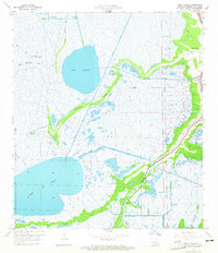
 1994 Lake Theriot1994 Print · USGSCoastal Louisiana in the mid-nineties shows a landscape where industrial canals and bayous intersect at the settlement of Theriot. Researchers can trace local landmarks like St Eloi Ch, Du Large Sch, and the expansive Lake Theriot.
 - 2012 Map of Lake Theriot, 2012 Print
 2012 Lake Theriot2012 Print · USGSCovers Theriot, including Terrebonne Parish, United States, and other nearby areas
 - 2015 Map of Lake Theriot, 2015 Print
 2015 Lake Theriot2015 Print · USGSCovers Theriot, including Terrebonne Parish, United States, and other nearby areas
 - 2018 Map of Lake Theriot, 2018 Print
 2018 Lake Theriot2018 Print · USGSCovers Theriot, including Terrebonne Parish, United States, and other nearby areas
 - 2020 Map of Lake Theriot, 2020 Print
 2020 Lake Theriot2020 Print · USGSCovers Theriot, including Terrebonne Parish, United States, and other nearby areas
 - 2024 Map of Lake Theriot, 2024 Print
 2024 Lake Theriot2024 Print · USGSThe Terrebonne Parish wetlands near Theriot are shown in detail, documenting the intersection of community life and the delta landscape. Researchers can trace family history at Saint Eloi or locate landmarks like Marmande Airport and the expansive Lake De Cade.
End of results
Showing maps 1-17 of 17
Top cities near Theriot
Frequently asked questions
- What are the different types of historical maps available for Theriot?
- What is the oldest map of Theriot?
- Where can I purchase historical maps of Theriot for my home or office?
- Where can I download high-res historical maps of Theriot?
- Are there historical topographic maps available for Theriot?
- Is there historical aerial imagery available for Theriot?
- Where are historical maps of Theriot sourced from?