
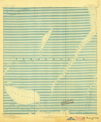
1894 Map of Bayou De Large
USGS Topo · Published 1894About this map
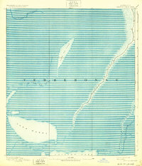
Bayou De Large snakes through this low-lying coastal landscape in the 1890s, serving as a primary corridor for settlement and navigation in Terrebonne. The survey reveals a region defined by its complex hydrology, where narrow ribbons of habitable land follow the natural levees of major waterways. Significant bodies of water such as Lake De Cade and the broad Lake Washa dominate the western portion of the sheet, while Bayou Grand Caillou marks the eastern edge of the survey area. This 1890 record documents the specific coastal morphology before the significant environmental shifts of the twentieth century, showing the original relationship between the bayous and the surrounding marshlands. Small structures are clustered along the banks of the larger bayous, illustrating the traditional line-settlement pattern characteristic of southern Louisiana's water-based economy.
Find a feature on this map
9 named features on this map. Tap any name to fly to it.
Don’t see what you’re looking for? This feature index may not catch every label — zoom into the map to look around manually.
Map Details
Editions of this 1894 Bayou De Large Map
4 editions found

Other maps of this area

1892 · Gibson
USGS Topo · 1:62,500

1892 · Houma
USGS Topo · 1:62,500

1894 · Dulac
USGS Topo · 1:62,500

1897 · Gibson
USGS Topo · 1:62,500

1932 · Lake Decade
USGS Topo · 1:62,500

1932 · Houma SW
USGS Topo · 1:31,680

1935 · Cocodrie
USGS Topo · 1:31,680

1935 · Theriot
USGS Topo · 1:31,680

1935 · Morgan City
USGS Topo · 1:62,500

1935 · Lake Mechant
USGS Topo · 1:31,680